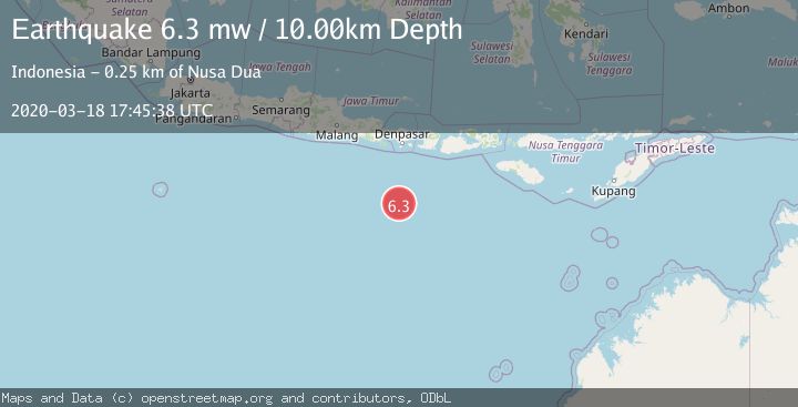
Earthquake SOUTH OF BALI, INDONESIA
Wed, 18 Mar 2020 17:45:38 GMT
Time5 years ago
Location
-11.0400, 115.1200
Depth
10.0 KM
Event Summary
A 6.3 magnitude earthquake struck on SOUTH OF BALI, INDONESIA, at Wed, 18 Mar 2020 17:45:38 GMT. Depth: 10km. Reviewed by EMSC seismologists, this strong quake occurred at a magnitude type of mw.
Magnitude
6.3
mw
Source
EMSC
Intensity
-
Agency Reports
1 Sources| Source | Magnitude | Depth | Time |
|---|---|---|---|
| EMSCPrimary | 6.3 | 10 km | 5 years ago |
Earthquake Details
AutomaticEvent IDemsc_EMSC_20200318_0000169
Tsunami PotentialNo
Magnitude Typemw
Nearest Places
- Lombok Basin165.1 km
- Bumi Linggah The Pratama Villas242.7 km
- Tukad Batukakeb243.8 km
- Tukad Jelijih243.8 km
- Tukad Gerombong243.8 km
Comments
Join the discussion about this event.
Latest Earthquakes
2.1Mag
Antofagasta, Chile
Time53 seconds ago
Depth82.15 km
SourceVYT (Automatic)
2.1Mag
Southern Alaska
Time3 minutes ago
Depth64.21 km
SourceVYT (Automatic)
2.5Mag
Central Alaska
Time9 minutes ago
Depth312.99 km
SourceVYT (Automatic)
3.6Mag
Banda Sea
Time15 minutes ago
Depth0.00 km
SourceVYT (Automatic)
1.9Mag
western Texas
Time20 minutes ago
Depth0.24 km
SourceVYT (Automatic)
Nearby Earthquakes
4.0Mag
SOUTH OF BALI, INDONESIA
Time4 years ago
Depth10.00 km
SourceDJA (Automatic)
4.0Mag
SOUTH OF BALI, INDONESIA
Time5 years ago
Depth10.00 km
SourceDJA (Automatic)
5.2Mag
SOUTH OF BALI, INDONESIA
Time5 years ago
Depth10.00 km
SourceEMSC (Automatic)
3.5Mag
SOUTH OF BALI, INDONESIA
Time1 month ago
Depth10.00 km
SourceBMKG (Automatic)
3.0Mag
SOUTH OF BALI, INDONESIA
Time5 years ago
Depth10.00 km
SourceDJA (Automatic)