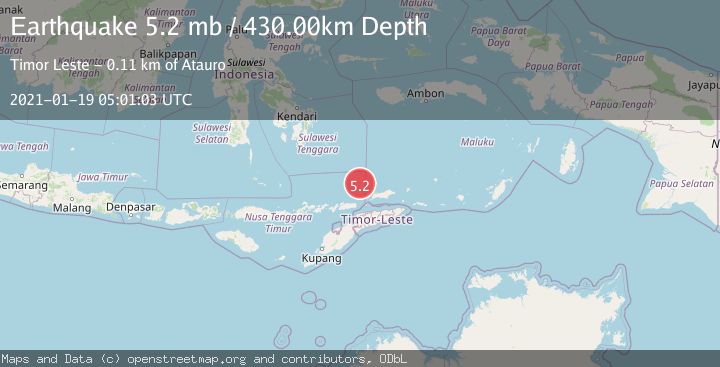
Earthquake KEPULAUAN BARAT DAYA, INDONESIA
Tue, 19 Jan 2021 05:01:03 GMT
Time5 years ago
Location
-7.3000, 125.3300
Depth
430.0 KM
Event Summary
A 5.2 magnitude earthquake struck on KEPULAUAN BARAT DAYA, INDONESIA, at Tue, 19 Jan 2021 05:01:03 GMT. Depth: 430km. Reviewed by EMSC seismologists, this moderate quake occurred at a magnitude type of mb.
Magnitude
5.2
mb
Source
EMSC
Intensity
-
Agency Reports
1 Sources| Source | Magnitude | Depth | Time |
|---|---|---|---|
| EMSCPrimary | 5.2 | 430 km | 5 years ago |
Earthquake Details
AutomaticEvent IDemsc_EMSC_20210119_0000038
Tsunami PotentialNo
Magnitude Typemb
Nearest Places
- Pulau Reong76.9 km
- Napar80.0 km
- Mamau80.4 km
- Tanjung Tutunlihuwai81.1 km
- Pogos81.2 km
Comments
Join the discussion about this event.
Latest Earthquakes
2.5Mag
Bering Strait
Time15 hours ago
Depth200.07 km
SourceVYT (Automatic)
2.3Mag
Sumbawa Region, Indonesia
Time15 hours ago
Depth10.00 km
SourceBMKG
1.6Mag
13 km ENE of Falls City, Texas
Time15 hours ago
Depth7.18 km
SourceUSGS (Automatic)
1.5Mag
EASTERN TURKEY
Time15 hours ago
Depth7.00 km
SourceAFAD (Automatic)
1.3Mag
5 km S of Cabazon, CA
Time15 hours ago
Depth5.80 km
SourceUSGS (Automatic)
Nearby Earthquakes
3.8Mag
Banda Sea
Time1 week ago
Depth172.35 km
SourceBMKG (Automatic)
5.0Mag
KEPULAUAN BARAT DAYA, INDONESIA
Time13 years ago
Depth508.00 km
SourceEMSC (Automatic)
5.0Mag
KEPULAUAN BARAT DAYA, INDONESIA
Time6 years ago
Depth439.00 km
SourceEMSC (Automatic)
5.4Mag
KEPULAUAN BARAT DAYA, INDONESIA
Time11 years ago
Depth490.00 km
SourceEMSC (Automatic)
4.0Mag
KEPULAUAN BARAT DAYA, INDONESIA
Time5 years ago
Depth452.00 km
SourceDJA (Automatic)