Earthquake STATE OF YAP, MICRONESIA
Fri, 26 Feb 2021 07:46:13 GMT
Time5 years ago
Location
8.5000, 137.7200
Depth
40.0 KM
Event Summary
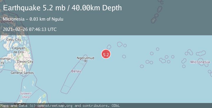
A 5.2 magnitude earthquake struck on STATE OF YAP, MICRONESIA, at Fri, 26 Feb 2021 07:46:13 GMT. Depth: 40km. Reviewed by EMSC seismologists, this moderate quake occurred at a magnitude type of mb.
Magnitude
5.2
mb
Source
EMSC
Intensity
-
Agency Reports
1 Sources| Source | Magnitude | Depth | Time |
|---|---|---|---|
| EMSCPrimary | 5.2 | 40 km | 5 years ago |
Earthquake Details
AutomaticEvent IDemsc_EMSC_20210226_0000056
Tsunami PotentialNo
Magnitude Typemb
Nearest Places
- 15.6 km
- 17.8 km
- 18.8 km
- 19.3 km
- 23.0 km
Comments
Join the discussion about this event.
Latest Earthquakes
2.0Mag
Valparaiso, Chile
Time3 hours ago
Depth4.64 km
SourceVYT (Automatic)
1.4Mag
Kodiak Island region, Alaska
Time3 hours ago
Depth47.12 km
SourceVYT (Automatic)
2.1Mag
NEVADA
Time3 hours ago
Depth4.90 km
SourceNN (Automatic)
4.6Mag
Rat Islands, Aleutian Islands, Alaska
Time3 hours ago
Depth10.00 km
SourceVYT (Automatic)
1.3Mag
11 km NW of Pinnacles, CA
Time3 hours ago
Depth8.23 km
SourceUSGS (Automatic)
Nearby Earthquakes
6.2Mag
STATE OF YAP, MICRONESIA
Time9 years ago
Depth20.00 km
SourceEMSC (Automatic)
4.4Mag
STATE OF YAP, MICRONESIA
Time1 month ago
Depth10.00 km
SourceNEIC (Automatic)
5.0Mag
STATE OF YAP, MICRONESIA
Time20 years ago
Depth10.00 km
SourceEMSC (Automatic)
5.1Mag
STATE OF YAP, MICRONESIA
Time10 years ago
Depth40.00 km
SourceEMSC (Automatic)
5.2Mag
STATE OF YAP, MICRONESIA
Time12 years ago
Depth49.00 km
SourceEMSC (Automatic)