Earthquake MINDANAO, PHILIPPINES
Wed, 17 Jan 2024 12:32:02 GMT
Time2 years ago
Location
8.5105, 126.4457
Depth
50.0 KM
Event Summary
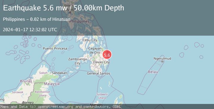
A 5.6 magnitude earthquake struck on MINDANAO, PHILIPPINES, at Wed, 17 Jan 2024 12:32:02 GMT. Depth: 50km. Reviewed by EMSC seismologists, this moderate quake occurred at a magnitude type of mw.
Magnitude
5.6
mw
Source
EMSC
Intensity
-
Agency Reports
1 Sources| Source | Magnitude | Depth | Time |
|---|---|---|---|
| EMSCPrimary | 5.6 | 50 km | 2 years ago |
Earthquake Details
AutomaticEvent IDemsc_EMSC_20240117_0000153
Tsunami PotentialNo
Magnitude Typemw
Nearest Places
- Lamon Point7.1 km
- Singag Island7.8 km
- Port Lamon8.1 km
- Lamon Pier9.2 km
- Bagasin Island9.4 km
Comments
Join the discussion about this event.
Latest Earthquakes
5.0Mag
Fox Islands, Aleutian Islands, Alaska
Time1 minute ago
Depth0.00 km
SourceVYT (Automatic)
3.4Mag
southern Peru
Time4 minutes ago
Depth204.47 km
SourceVYT (Automatic)
2.1Mag
SAN FRANCISCO BAY AREA, CALIF.
Time7 minutes ago
Depth6.40 km
SourceNC (Automatic)
2.4Mag
Fox Islands, Aleutian Islands, Alaska
Time7 minutes ago
Depth44.43 km
SourceVYT (Automatic)
2.4Mag
British Columbia, Canada
Time8 minutes ago
Depth3.91 km
SourceVYT (Automatic)
Nearby Earthquakes
3.0Mag
MINDANAO, PHILIPPINES
Time5 years ago
Depth25.00 km
SourcePIVS (Automatic)
3.0Mag
MINDANAO, PHILIPPINES
Time5 years ago
Depth25.00 km
SourcePIVS (Automatic)
3.0Mag
MINDANAO, PHILIPPINES
Time1 year ago
Depth6.00 km
SourcePIVS (Automatic)
3.0Mag
MINDANAO, PHILIPPINES
Time2 years ago
Depth21.00 km
SourcePIVS (Automatic)
3.0Mag
MINDANAO, PHILIPPINES
Time2 years ago
Depth24.00 km
SourcePIVS (Automatic)