Earthquake PHILIPPINE ISLANDS REGION
Tue, 13 Jan 2026 18:00:49 GMT
Time1 month ago
Location
5.5000, 127.3655
Depth
160.0 KM
Event Summary
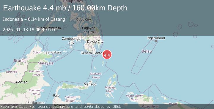
A 4.4 magnitude earthquake struck on PHILIPPINE ISLANDS REGION, at Tue, 13 Jan 2026 18:00:49 GMT. Depth: 160km. Reviewed by EMSC seismologists, this light quake occurred at a magnitude type of mb.
Magnitude
4.4
mb
Source
EMSC
Intensity
-
Agency Reports
1 Sources| Source | Magnitude | Depth | Time |
|---|---|---|---|
| EMSCPrimary | 4.4 | 160 km | 1 month ago |
Earthquake Details
AutomaticEvent IDemsc_EMSC_20260113_0000260
Tsunami PotentialNo
Magnitude Typemb
Nearest Places
- Pulau Garat85.0 km
- Tanjung Dapapa86.2 km
- Desa Marampit86.4 km
- Desa Marampit Timur86.6 km
- Desa Pulau Miangas86.7 km
Comments
Join the discussion about this event.
Latest Earthquakes
0.9Mag
Washington
Time1 minute ago
Depth0.61 km
SourceVYT (Automatic)
1.8Mag
59 km S of Whites City, New Mexico
Time9 minutes ago
Depth4.51 km
SourceUSGS (Automatic)
2.4Mag
Antofagasta, Chile
Time10 minutes ago
Depth0.00 km
SourceVYT (Automatic)
2.2Mag
Sumbawa Region, Indonesia
Time17 minutes ago
Depth125.89 km
SourceBMKG
1.0Mag
8 km WNW of The Geysers, CA
Time18 minutes ago
Depth0.69 km
SourceUSGS (Automatic)
Nearby Earthquakes
3.0Mag
PHILIPPINE ISLANDS REGION
Time1 year ago
Depth3.00 km
SourcePIVS (Automatic)
3.0Mag
PHILIPPINE ISLANDS REGION
Time10 months ago
Depth11.00 km
SourcePIVS (Automatic)
3.0Mag
PHILIPPINE ISLANDS REGION
Time4 years ago
Depth13.00 km
SourcePIVS (Automatic)
5.2Mag
PHILIPPINE ISLANDS REGION
Time17 years ago
Depth52.00 km
SourceEMSC (Automatic)
3.0Mag
PHILIPPINE ISLANDS REGION
Time5 years ago
Depth15.00 km
SourcePIVS (Automatic)