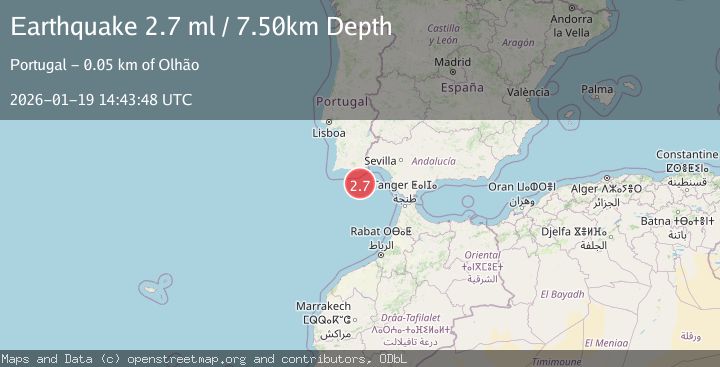
Earthquake STRAIT OF GIBRALTAR
Mon, 19 Jan 2026 14:43:48 GMT
Time1 month ago
Location
36.5691, -7.7400
Depth
7.5 KM
Event Summary
A 2.7 magnitude earthquake struck on STRAIT OF GIBRALTAR, at Mon, 19 Jan 2026 14:43:48 GMT. Depth: 7.5km. Reviewed by EMSC seismologists, this minor quake occurred at a magnitude type of ml.
Magnitude
2.7
ml
Source
EMSC
Intensity
-
Agency Reports
1 Sources| Source | Magnitude | Depth | Time |
|---|---|---|---|
| EMSCPrimary | 2.7 | 8 km | 1 month ago |
Earthquake Details
AutomaticEvent IDemsc_EMSC_20260119_0000187
Tsunami PotentialNo
Magnitude Typeml
Nearest Places
- Ribeira da Pardiela10.2 km
- Faro Canyon35.0 km
- Barra Nova45.4 km
- Praia Da Ilha Deserta45.5 km
- Cabo de Santa Maria45.5 km
Comments
Join the discussion about this event.
Latest Earthquakes
2.1Mag
Tarapaca, Chile
Time43 seconds ago
Depth115.60 km
SourceVYT (Automatic)
1.2Mag
19 km NNE of Indio, CA
Time3 minutes ago
Depth4.01 km
SourceUSGS (Automatic)
2.5Mag
northwestern Russia
Time6 minutes ago
Depth0.00 km
SourceVYT (Automatic)
1.8Mag
54 km S of Whites City, New Mexico
Time7 minutes ago
Depth6.07 km
SourceUSGS (Automatic)
2.0Mag
Arizona
Time10 minutes ago
Depth8.18 km
SourceVYT (Automatic)
Nearby Earthquakes
1.6Mag
STRAIT OF GIBRALTAR
Time1 month ago
Depth27.50 km
SourceIGN (Automatic)
1.5Mag
STRAIT OF GIBRALTAR
Time1 month ago
Depth0.00 km
SourceIGN (Automatic)
3.0Mag
STRAIT OF GIBRALTAR
Time25 years ago
Depth15.00 km
SourceEMSC (Automatic)
3.0Mag
STRAIT OF GIBRALTAR
Time25 years ago
Depth15.00 km
SourceEMSC (Automatic)
3.0Mag
STRAIT OF GIBRALTAR
Time8 years ago
Depth60.00 km
SourceEMSC (Automatic)