Earthquake PHILIPPINE ISLANDS REGION
Wed, 11 Feb 2026 22:28:01 GMT
Time2 months ago
Location
20.4468, 120.0196
Depth
25.0 KM
Event Summary
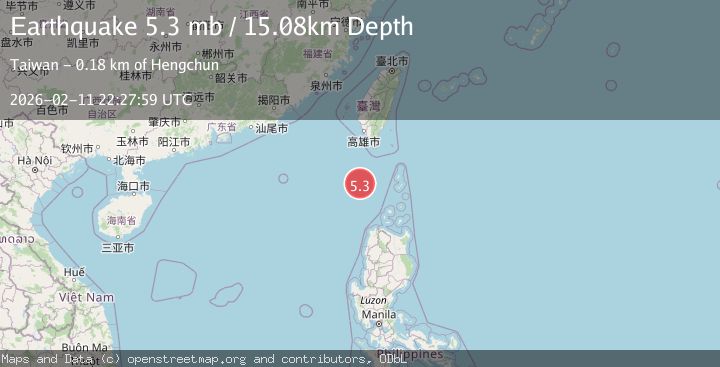
A 5.3 magnitude earthquake struck on PHILIPPINE ISLANDS REGION, at Wed, 11 Feb 2026 22:28:01 GMT. Depth: 25km. Reviewed by EMSC seismologists, this moderate quake occurred at a magnitude type of mb.
Magnitude
5.3
mb
Source
EMSC
Intensity
II
Agency Reports
3 Sources| Source | Magnitude | Depth | Time |
|---|---|---|---|
| EMSCPrimary | 5.3 | 25 km | 2 months ago |
| NEIC | 5.3 | 15 km | 2 months ago |
| USGS | 5.3 | 15 km | 2 months ago |
Earthquake Details
AutomaticEvent IDemsc_EMSC_20260211_0000355
QualityS
Tsunami PotentialNo
Magnitude Typemb
Last Update2 months ago
Nearest Places
Possibly felt by: 388.9K
- IIHengchun188.7 km31.3K people
- IIItbayat193.4 km
- IISabtang193.4 km
- IIIvana197.7 km
- IIUyugan200.2 km
- IIMahatao200.9 km
- IIBasco203.2 km7.3K people
- IIBurgos224.4 km
- IIPagudpud224.5 km4.9K people
- IIBangui226.3 km2.5K people
- IIDavila227.2 km3.5K people
- IIDonggang228.8 km47.7K people
- IIDumalneg229.1 km
- 232.9 km10.6K people
- 232.9 km
- 236.8 km3K people
- 238.7 km
- 243.1 km1.5M people
- 243.3 km5.8K people
- 244.9 km
- 251.8 km9.6K people
- 252.1 km
- 253.7 km2.3K people
- 255.3 km5.3K people
- 257.3 km102.1K people
- 260.0 km34.2K people
- 260.2 km2.1K people
- 262.9 km5.8K people
- 264.0 km3.5K people
- 264.5 km2.8K people
- IBagu264.9 km2.1K people
- 265.2 km2.2K people
- 265.4 km
- IBaay265.4 km3K people
- 265.9 km
- 268.6 km2.4K people
- 268.6 km2.2K people
- 268.6 km2.1K people
- 270.1 km6.9K people
- 270.1 km3.6K people
- 270.4 km3.3K people
- 272.0 km55.5K people
- 272.3 km3K people
- 273.2 km9.3K people
- 273.3 km3.7K people
- 273.9 km3.3K people
- ILuna274.2 km
- 274.5 km
- 275.2 km5.6K people
- 275.4 km
- 276.1 km2.4K people
- 277.0 km3.4K people
- 277.4 km2.6K people
- 278.6 km2.3K people
- 279.6 km2.8K people
- 282.2 km3.6K people
- 282.3 km
- 282.5 km2.3K people
- 282.6 km
- 283.6 km771.2K people
- 284.3 km4.3K people
- 284.6 km2.1K people
- 284.8 km2.2K people
- 284.8 km2.3K people
- 287.6 km233.7K people
- 288.0 km33.2K people
- 288.2 km4.2K people
- 289.4 km
- 290.6 km3.1K people
- 294.9 km3.6K people
- 296.4 km2.3K people
- 297.1 km4.4K people
- 297.5 km
- 298.6 km6.9K people
- 299.9 km3.2K people
- 301.3 km16.6K people
- 302.5 km2.3K people
- 304.1 km2.2K people
- 304.3 km3.1K people
- 306.3 km3.1K people
- 306.6 km3.8K people
- 308.4 km3.6K people
- 308.7 km3.2K people
- 309.1 km2.6K people
- 309.7 km11.2K people
- 309.8 km4K people
- 310.0 km4.6K people
- 310.5 km3.3K people
- 311.6 km
- 312.1 km2.1K people
- 312.5 km6.4K people
- 312.6 km
- 312.9 km13.7K people
- 313.2 km6.3K people
- 315.1 km2.6K people
- 315.3 km3.6K people
- 315.3 km
- 316.0 km2.8K people
- 316.1 km3.4K people
- 316.3 km
- 316.6 km
- 317.6 km2.5K people
- 318.9 km
- 319.1 km
- 319.1 km3.3K people
- 319.4 km2.5K people
- 319.4 km
- 319.5 km7.2K people
- 319.6 km2.4K people
- 320.5 km2.9K people
- 320.6 km10.1K people
- 320.8 km2.5K people
- 320.8 km
- 321.0 km2.5K people
- 321.2 km3K people
- 321.6 km2.5K people
- 321.6 km2.5K people
- 321.7 km48.5K people
- 322.3 km
- 323.2 km3.4K people
- 324.0 km
- 324.2 km
- 324.5 km2.2K people
- 325.2 km2.4K people
- 325.5 km2.7K people
- 325.9 km2.6K people
- 326.5 km2.9K people
- 327.2 km
- 327.3 km
- 328.0 km4.9K people
- 329.0 km
- 329.9 km2.5K people
- 329.9 km2.4K people
- 330.0 km2.2K people
- 331.1 km4.7K people
- 331.4 km
- 332.1 km2.3K people
- 332.4 km2.1K people
- IPiat332.7 km6K people
- 334.1 km2.5K people
- 334.2 km3.5K people
- 335.1 km2.1K people
- 335.7 km2.9K people
- 336.2 km2.4K people
- 336.5 km
- ITuao337.1 km2.2K people
- 337.2 km
- 337.3 km2.6K people
- 337.8 km
- 338.0 km3.1K people
- 338.0 km4.1K people
- 338.6 km2.4K people
- 339.0 km4.6K people
- 339.3 km2.1K people
- 340.1 km
- 340.2 km3K people
- 340.6 km
- 340.7 km5K people
- 341.1 km2.4K people
- IPata341.3 km2.2K people
- 342.1 km4K people
- 342.4 km
- 342.8 km
- 342.9 km2.3K people
- 343.5 km2.8K people
- 343.8 km2.1K people
- 344.2 km4.5K people
- 344.5 km2.2K people
- 345.0 km4.1K people
- 345.7 km
- 345.9 km3.7K people
- 346.2 km
- ISuso346.4 km2.3K people
- 346.5 km
- 347.3 km
- 348.6 km2.1K people
- 348.9 km2.4K people
- 349.1 km6K people
- 349.5 km
- 349.6 km8.2K people
- 349.6 km56.4K people
- 349.9 km3.3K people
- 349.9 km
- 350.3 km3.9K people
- 353.2 km3.4K people
- 353.4 km
- 354.1 km2.6K people
- ILuba355.1 km
- IGadu355.1 km2.9K people
- 355.3 km11.9K people
- 355.9 km6.4K people
- 356.6 km2.2K people
- 356.9 km71.5K people
- 357.2 km
- 357.3 km2.4K people
- 358.3 km2.4K people
- 359.0 km2.9K people
- 360.2 km10.1K people
- 360.6 km2.2K people
- 360.6 km
- 361.4 km2.2K people
- ITubo361.5 km
- 361.6 km2.2K people
- 362.0 km2.2K people
- 362.1 km166.3K people
- ILapi362.1 km2.8K people
- 362.2 km2.9K people
- 362.7 km3K people
- 362.9 km
- 363.4 km2.7K people
- 363.5 km3K people
- 363.5 km
- 363.5 km3K people
- 364.0 km27K people
- ILaya364.1 km3.8K people
- 364.5 km11.2K people
- 364.6 km2.9K people
- 365.5 km2.6K people
- 365.9 km
- 366.3 km9.7K people
- 366.5 km2.6K people
- 366.8 km104.7K people
- 366.8 km2.7K people
- 367.0 km5.3K people
- 367.3 km2.2K people
- 367.5 km2.3K people
- 370.1 km
Felt Reports0
Did you feel this earthquake? Report it to help others.
No reports yet
Be the first to report this earthquake!
Latest Earthquakes
Loading...
Nearby Earthquakes
3.0Mag
BABUYAN ISL REGION, PHILIPPINES
Time1 week ago
Depth9.00 km
SourcePIVS (Automatic)
3.0Mag
BABUYAN ISL REGION, PHILIPPINES
Time2 weeks ago
Depth12.00 km
SourcePIVS (Automatic)
3.3Mag
PHILIPPINE ISLANDS REGION
Time3 weeks ago
Depth21.00 km
SourcePIVS (Automatic)
3.6Mag
PHILIPPINE ISLANDS REGION
Time3 weeks ago
Depth27.00 km
SourcePIVS (Automatic)
3.8Mag
BABUYAN ISL REGION, PHILIPPINES
Time1 month ago
Depth11.00 km
SourcePIVS (Automatic)