Earthquake NEAR EAST COAST OF KAMCHATKA
Mon, 16 Feb 2026 21:42:53 GMT
Time4 days ago
Location
51.2300, 157.7866
Depth
47.0 KM
Event Summary
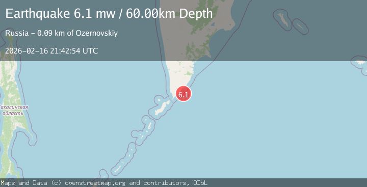
A 6.1 magnitude earthquake struck on NEAR EAST COAST OF KAMCHATKA, at Mon, 16 Feb 2026 21:42:53 GMT. Depth: 47km. Reviewed by EMSC seismologists, this strong quake occurred at a magnitude type of m.
Magnitude
6.1
m
Source
EMSC
Intensity
-
Agency Reports
5 Sources| Source | Magnitude | Depth | Time |
|---|---|---|---|
| EMSCPrimary | 6.1 | 47 km | 4 days ago |
| GFZ | 6.0 | 57 km | 4 days ago |
| NEIC | 6.0 | 57 km | 4 days ago |
| USGS | 6.0 | 57 km | 4 days ago |
| GSRAS | 6.1 | 60 km | 4 days ago |
Earthquake Details
AutomaticEvent IDemsc_EMSC_20260216_0000327
Tsunami PotentialNo
Magnitude Typem
Nearest Places
- 25.0 km
- 27.0 km
- 27.6 km
- 27.9 km
- 28.2 km
Comments
Join the discussion about this event.
Latest Earthquakes
1.2Mag
WESTERN TURKEY
Time9 hours ago
Depth7.60 km
SourceAFAD (Automatic)
3.5Mag
Flores region, Indonesia
Time9 hours ago
Depth638.55 km
SourceVYT (Automatic)
3.0Mag
South of Java, Indonesia
Time9 hours ago
Depth26.04 km
SourceBMKG
2.1Mag
Java, Indonesia
Time9 hours ago
Depth128.82 km
SourceBMKG
1.8Mag
60 km S of Whites City, New Mexico
Time9 hours ago
Depth3.28 km
SourceUSGS (Automatic)
Nearby Earthquakes
5.3Mag
NEAR EAST COAST OF KAMCHATKA
Time6 months ago
Depth20.00 km
SourceEMSC (Automatic)
5.9Mag
NEAR EAST COAST OF KAMCHATKA
Time5 months ago
Depth54.50 km
SourceEMSC (Automatic)
3.9Mag
NEAR EAST COAST OF KAMCHATKA
Time1 month ago
Depth33.00 km
SourceGSRAS (Automatic)
6.5Mag
NEAR EAST COAST OF KAMCHATKA
Time19 years ago
Depth60.00 km
SourceEMSC (Automatic)
5.2Mag
NEAR EAST COAST OF KAMCHATKA
Time4 months ago
Depth47.00 km
SourceEMSC (Automatic)