Earthquake BALI SEA
Tue, 17 Sep 2013 23:53:36 GMT
Time12 years ago
Location
-7.9100, 117.9100
Depth
14.0 KM
Event Summary
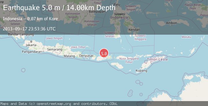
A 5.0 magnitude earthquake struck on BALI SEA, at Tue, 17 Sep 2013 23:53:36 GMT. Depth: 14km. Reviewed by GFZ seismologists, this moderate quake occurred at a magnitude type of m.
Magnitude
5.0
m
Source
GFZ
Intensity
-
Agency Reports
1 Sources| Source | Magnitude | Depth | Time |
|---|---|---|---|
| GFZPrimary | 5.0 | 14 km | 12 years ago |
Earthquake Details
AutomaticEvent IDemsc_GFZ_20130917_0000097
Tsunami PotentialNo
Magnitude Typem
Nearest Places
- 19.4 km
- 23.9 km
- 24.1 km
- 25.9 km
- 26.0 km
Comments
Join the discussion about this event.
Latest Earthquakes
1.7Mag
San Pedro Channel, California
Time1 minute ago
Depth15.26 km
SourceVYT (Automatic)
1.8Mag
Kenai Peninsula, Alaska
Time7 minutes ago
Depth103.15 km
SourceVYT (Automatic)
2.8Mag
WESTERN TURKEY
Time9 minutes ago
Depth8.40 km
SourceAFAD (Automatic)
2.3Mag
Antofagasta, Chile
Time10 minutes ago
Depth133.79 km
SourceVYT (Automatic)
3.6Mag
West Papua, Indonesia
Time14 minutes ago
Depth10.00 km
SourceBMKG
Nearby Earthquakes
3.0Mag
BALI SEA
Time6 years ago
Depth11.00 km
SourceDJA (Automatic)
3.0Mag
BALI SEA
Time3 years ago
Depth28.00 km
SourceDJA (Automatic)
3.0Mag
BALI SEA
Time1 year ago
Depth6.00 km
SourceBMKG (Automatic)
3.0Mag
SUMBAWA REGION, INDONESIA
Time7 months ago
Depth21.00 km
SourceBMKG (Automatic)
4.0Mag
BALI SEA
Time2 years ago
Depth23.00 km
SourceDJA (Automatic)