Earthquake MYANMAR
Mon, 16 Feb 2026 22:50:48 GMT
Time1 week ago
Location
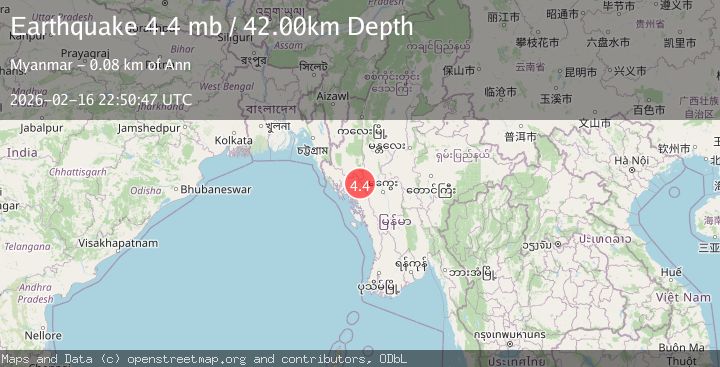
20.4650, 93.8750
Depth
40.4 KM
Event Summary
A 4.5 magnitude earthquake struck on MYANMAR, at Mon, 16 Feb 2026 22:50:48 GMT. Depth: 40.4km. Reviewed by GFZ seismologists, this light quake occurred at a magnitude type of mb.
Magnitude
4.5
mb
Source
GFZ
Intensity
-
Agency Reports
2 Sources| Source | Magnitude | Depth | Time |
|---|---|---|---|
| GFZPrimary | 4.5 | 40 km | 1 week ago |
| NEIC | 4.4 | 42 km | 1 week ago |
Earthquake Details
AutomaticEvent IDemsc_GFZ_20260216_0000389
Tsunami PotentialNo
Magnitude Typemb
Nearest Places
- 4.8 km
- 5.5 km
- 8.0 km
- 9.1 km
- 9.3 km
Comments
Join the discussion about this event.
Latest Earthquakes
2.3Mag
ISLAND OF HAWAII, HAWAII
Time9 minutes ago
Depth0.20 km
SourceHV (Automatic)
2.7Mag
Southern Alaska
Time12 minutes ago
Depth56.64 km
SourceVYT (Automatic)
3.6Mag
Antofagasta, Chile
Time16 minutes ago
Depth136.11 km
SourceVYT (Automatic)
2.3Mag
Atacama, Chile
Time19 minutes ago
Depth10.00 km
SourceVYT (Automatic)
1.8Mag
1 km WSW of Anderson Springs, CA
Time20 minutes ago
Depth2.84 km
SourceUSGS (Automatic)
Nearby Earthquakes
6.0Mag
MYANMAR
Time3 weeks ago
Depth57.00 km
SourceEMSC (Automatic)
5.0Mag
MYANMAR
Time12 years ago
Depth30.00 km
SourceEMSC (Automatic)
5.2Mag
MYANMAR
Time18 years ago
Depth31.00 km
SourceEMSC (Automatic)
5.4Mag
MYANMAR
Time11 years ago
Depth80.00 km
SourceEMSC (Automatic)
5.0Mag
MYANMAR
Time19 years ago
Depth60.00 km
SourceEMSC (Automatic)