Earthquake PHILIPPINE ISLANDS REGION
Thu, 19 Feb 2026 14:43:03 GMT
Time1 hour ago
Location
10.1180, 126.7270
Depth
10.0 KM
Event Summary
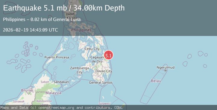
A 5.1 magnitude earthquake struck on PHILIPPINE ISLANDS REGION, at Thu, 19 Feb 2026 14:43:03 GMT. Depth: 10km. Reviewed by GFZ seismologists, this moderate quake occurred at a magnitude type of mb.
Magnitude
5.1
mb
Source
GFZ
Intensity
-
Agency Reports
2 Sources| Source | Magnitude | Depth | Time |
|---|---|---|---|
| GFZPrimary | 5.0 | 10 km | 1 hour ago |
| EMSC | 5.1 | 34 km | 1 hour ago |
Earthquake Details
AutomaticEvent IDemsc_GFZ_20260219_0000233
Tsunami PotentialNo
Magnitude Typemb
Nearest Places
- Emden Deep60.8 km
- Tuason Point70.2 km
- Cabalauan River70.7 km
- Arena Point70.9 km
- Sharp Point71.0 km
Comments
Join the discussion about this event.
Latest Earthquakes
1.3Mag
8 km NW of The Geysers, CA
Time1 hour ago
Depth1.51 km
SourceUSGS (Automatic)
2.2Mag
Southeastern Alaska
Time1 hour ago
Depth0.00 km
SourceVYT (Automatic)
1.9Mag
Tarapaca, Chile
Time1 hour ago
Depth107.06 km
SourceVYT (Automatic)
3.0Mag
Java, Indonesia
Time1 hour ago
Depth0.00 km
SourceVYT (Automatic)
0.6Mag
2 km W of Anza, CA
Time1 hour ago
Depth2.81 km
SourceUSGS (Automatic)
Nearby Earthquakes
4.0Mag
PHILIPPINE ISLANDS REGION
Time1 year ago
Depth10.00 km
SourcePIVS (Automatic)
4.0Mag
PHILIPPINE ISLANDS REGION
Time1 year ago
Depth10.00 km
SourcePIVS (Automatic)
4.0Mag
PHILIPPINE ISLANDS REGION
Time1 year ago
Depth10.00 km
SourcePIVS (Automatic)
4.0Mag
PHILIPPINE ISLANDS REGION
Time1 year ago
Depth10.00 km
SourcePIVS (Automatic)
3.0Mag
PHILIPPINE ISLANDS REGION
Time2 years ago
Depth18.00 km
SourcePIVS (Automatic)