Earthquake SOUTH OF KERMADEC ISLANDS
Mon, 23 Nov 2020 01:43:57 GMT
Time5 years ago
Location
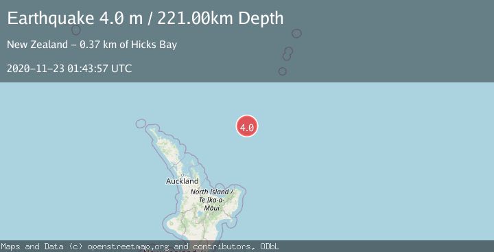
-34.2800, 178.9300
Depth
221.0 KM
Event Summary
A 4.0 magnitude earthquake struck on SOUTH OF KERMADEC ISLANDS, at Mon, 23 Nov 2020 01:43:57 GMT. Depth: 221km. Reviewed by GNS seismologists, this light quake occurred at a magnitude type of m.
Magnitude
4.0
m
Source
GNS
Intensity
-
Agency Reports
1 Sources| Source | Magnitude | Depth | Time |
|---|---|---|---|
| GNSPrimary | 4.0 | 221 km | 5 years ago |
Earthquake Details
AutomaticEvent IDemsc_GNS_20201123_0000011
Tsunami PotentialNo
Magnitude Typem
Nearest Places
- Kibblewhite Seamount46.9 km
- Giljanes Seamount63.7 km
- Brothers Seamount67.1 km
- Rapuhia Seamount69.6 km
- James Healy Seamount78.1 km
Comments
Join the discussion about this event.
Latest Earthquakes
2.2Mag
Central Alaska
Time5 minutes ago
Depth0.00 km
SourceVYT (Automatic)
2.2Mag
Tarapaca, Chile
Time6 minutes ago
Depth88.01 km
SourceVYT (Automatic)
2.1Mag
Poland
Time6 minutes ago
Depth0.12 km
SourceVYT (Automatic)
1.1Mag
3 km WSW of Cobb, CA
Time8 minutes ago
Depth1.86 km
SourceUSGS (Automatic)
1.3Mag
Alaska Peninsula
Time10 minutes ago
Depth62.50 km
SourceVYT (Automatic)
Nearby Earthquakes
4.0Mag
SOUTH OF KERMADEC ISLANDS
Time3 years ago
Depth264.00 km
SourceGNS (Automatic)
5.3Mag
SOUTH OF KERMADEC ISLANDS
Time21 years ago
Depth33.00 km
SourceEMSC (Automatic)
4.0Mag
SOUTH OF KERMADEC ISLANDS
Time5 years ago
Depth226.00 km
SourceGNS (Automatic)
4.0Mag
SOUTH OF KERMADEC ISLANDS
Time4 years ago
Depth100.00 km
SourceGNS (Automatic)
4.0Mag
SOUTH OF KERMADEC ISLANDS
Time1 year ago
Depth255.80 km
SourceGNS (Automatic)