Earthquake SOUTH OF KERMADEC ISLANDS
Mon, 02 Aug 2021 14:13:46 GMT
Time4 years ago
Location
-32.2700, 178.3500
Depth
302.0 KM
Event Summary
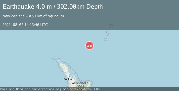
A 4.0 magnitude earthquake struck on SOUTH OF KERMADEC ISLANDS, at Mon, 02 Aug 2021 14:13:46 GMT. Depth: 302km. Reviewed by GNS seismologists, this light quake occurred at a magnitude type of m.
Magnitude
4.0
m
Source
GNS
Intensity
-
Agency Reports
1 Sources| Source | Magnitude | Depth | Time |
|---|---|---|---|
| GNSPrimary | 4.0 | 302 km | 4 years ago |
Earthquake Details
AutomaticEvent IDemsc_GNS_20210802_0000168
QualityS
Tsunami PotentialNo
Magnitude Typem
Last Update5 months ago
Felt Reports0
Did you feel this earthquake? Report it to help others.
No reports yet
Be the first to report this earthquake!
Latest Earthquakes
Loading...
Nearby Earthquakes
3.4Mag
SOUTH OF KERMADEC ISLANDS
Time5 days ago
Depth300.00 km
SourceGNS (Automatic)
3.1Mag
SOUTH OF KERMADEC ISLANDS
Time1 month ago
Depth400.00 km
SourceGNS (Automatic)
4.0Mag
Kermadec Islands region
Time1 month ago
Depth601.81 km
SourceVYT (Automatic)
3.6Mag
SOUTH OF KERMADEC ISLANDS
Time2 months ago
Depth500.00 km
SourceGNS (Automatic)
3.7Mag
south of the Kermadec Islands
Time3 months ago
Depth403.32 km
SourceVYT (Automatic)