Earthquake SOUTH OF KERMADEC ISLANDS
Sat, 31 Jan 2026 17:20:45 GMT
Time2 hours ago
Location
-34.8014, 178.6823
Depth
100.0 KM
Event Summary
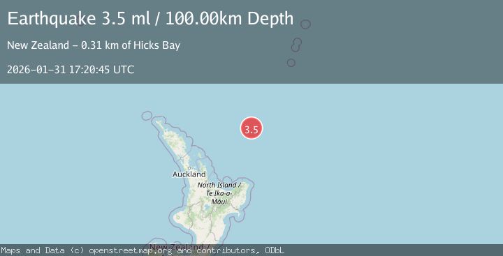
A 3.5 magnitude earthquake struck on SOUTH OF KERMADEC ISLANDS, at Sat, 31 Jan 2026 17:20:45 GMT. Depth: 100km. Reviewed by GNS seismologists, this minor quake occurred at a magnitude type of ml.
Magnitude
3.5
ml
Source
GNS
Intensity
-
Agency Reports
1 Sources| Source | Magnitude | Depth | Time |
|---|---|---|---|
| GNSPrimary | 3.5 | 100 km | 2 hours ago |
Earthquake Details
AutomaticEvent IDemsc_GNS_20260131_0000277
Tsunami PotentialNo
Magnitude Typeml
Nearest Places
- Giljanes Seamount9.9 km
- Rapuhia Seamount18.5 km
- James Healy Seamount34.1 km
- Brothers Seamount35.4 km
- Cotton Seamount38.5 km
Comments
Join the discussion about this event.
Latest Earthquakes
1.0Mag
14 km NNW of Johannesburg, CA
Time1 hour ago
Depth4.29 km
SourceUSGS (Automatic)
3.1Mag
SOUTH ISLAND OF NEW ZEALAND
Time2 hours ago
Depth5.00 km
SourceGNS (Automatic)
5.0Mag
Banda Sea
Time2 hours ago
Depth160.88 km
SourceBMKG (Automatic)
2.5Mag
SIKKIM, INDIA
Time2 hours ago
Depth25.00 km
SourceNDI (Automatic)
1.0Mag
26 km ENE of Cantwell, Alaska
Time2 hours ago
Depth2.90 km
SourceUSGS (Automatic)
Nearby Earthquakes
4.1Mag
SOUTH OF KERMADEC ISLANDS
Time1 week ago
Depth457.60 km
SourceGNS (Automatic)
3.3Mag
OFF E. COAST OF N. ISLAND, N.Z.
Time4 days ago
Depth315.20 km
SourceGNS (Automatic)
3.9Mag
OFF E. COAST OF N. ISLAND, N.Z.
Time8 hours ago
Depth33.00 km
SourceGNS (Automatic)
3.7Mag
NORTH OF NEW ZEALAND
Time3 hours ago
Depth421.50 km
SourceGNS (Automatic)
4.0Mag
OFF E. COAST OF N. ISLAND, N.Z.
Time1 week ago
Depth273.10 km
SourceGNS (Automatic)