Earthquake NORTH ISLAND OF NEW ZEALAND
Mon, 16 Feb 2026 00:27:10 GMT
Time3 days ago
Location
-41.1594, 175.1312
Depth
21.7 KM
Event Summary
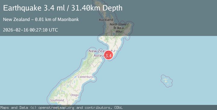
A 3.4 magnitude earthquake struck on NORTH ISLAND OF NEW ZEALAND, at Mon, 16 Feb 2026 00:27:10 GMT. Depth: 21.7km. Reviewed by GNS seismologists, this minor quake occurred at a magnitude type of m.
Magnitude
3.4
m
Source
GNS
Intensity
-
Agency Reports
3 Sources| Source | Magnitude | Depth | Time |
|---|---|---|---|
| GNSPrimary | 3.4 | 22 km | 3 days ago |
| NEIC | 3.4 | 31 km | 3 days ago |
| EMSC | 3.4 | 31 km | 3 days ago |
Earthquake Details
AutomaticEvent IDemsc_GNS_20260216_0000003
Tsunami PotentialNo
Magnitude Typem
Nearest Places
- Redington Stream0.8 km
- Pakuratahi River1.9 km
- Climie1.9 km
- Rimutaka Range3.1 km
- Climie Creek3.4 km
Comments
Join the discussion about this event.
Latest Earthquakes
1.2Mag
Southern Alaska
Time13 hours ago
Depth37.11 km
SourceVYT (Automatic)
3.0Mag
Seram, Indonesia
Time13 hours ago
Depth12.36 km
SourceBMKG
1.1Mag
Washington
Time13 hours ago
Depth9.64 km
SourceVYT (Automatic)
1.9Mag
32 km NW of Toyah, Texas
Time13 hours ago
Depth4.09 km
SourceUSGS (Automatic)
1.7Mag
western Texas
Time13 hours ago
Depth3.42 km
SourceVYT (Automatic)
Nearby Earthquakes
3.0Mag
NORTH ISLAND OF NEW ZEALAND
Time4 months ago
Depth5.90 km
SourceGNS (Automatic)
3.0Mag
NORTH ISLAND OF NEW ZEALAND
Time1 year ago
Depth14.90 km
SourceGNS (Automatic)
3.0Mag
NORTH ISLAND OF NEW ZEALAND
Time1 year ago
Depth33.50 km
SourceGNS (Automatic)
3.0Mag
COOK STRAIT, NEW ZEALAND
Time1 year ago
Depth15.90 km
SourceGNS (Automatic)
3.0Mag
NORTH ISLAND OF NEW ZEALAND
Time1 year ago
Depth27.30 km
SourceGNS (Automatic)