Earthquake SOUTH OF KERMADEC ISLANDS
Sat, 28 Feb 2026 04:17:28 GMT
Time1 hour ago
Location
-32.1763, 179.7242
Depth
438.5 KM
Event Summary
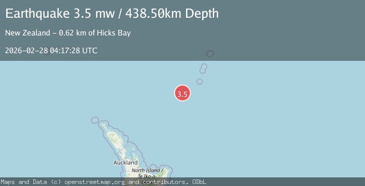
A 3.5 magnitude earthquake struck on SOUTH OF KERMADEC ISLANDS, at Sat, 28 Feb 2026 04:17:28 GMT. Depth: 438.5km. Reviewed by GNS seismologists, this minor quake occurred at a magnitude type of mw.
Magnitude
3.5
mw
Source
GNS
Intensity
-
Agency Reports
1 Sources| Source | Magnitude | Depth | Time |
|---|---|---|---|
| GNSPrimary | 3.5 | 439 km | 1 hour ago |
Earthquake Details
AutomaticEvent IDemsc_GNS_20260228_0000052
Tsunami PotentialNo
Magnitude Typemw
Nearest Places
- 61.7 km
- 68.7 km
- 77.9 km
- 105.0 km
- 113.7 km
Comments
Join the discussion about this event.
Latest Earthquakes
1.7Mag
Southern Alaska
Time1 hour ago
Depth0.00 km
SourceVYT (Automatic)
2.3Mag
Flores Region, Indonesia
Time1 hour ago
Depth10.00 km
SourceBMKG
2.7Mag
9 km SE of Ratliff City, Oklahoma
Time1 hour ago
Depth0.76 km
SourceUSGS (Automatic)
1.8Mag
Southeastern Alaska
Time1 hour ago
Depth0.12 km
SourceVYT (Automatic)
5.0Mag
Celebes Sea
Time1 hour ago
Depth375.12 km
SourceVYT (Automatic)
Nearby Earthquakes
4.0Mag
SOUTH OF KERMADEC ISLANDS
Time3 years ago
Depth300.00 km
SourceGNS (Automatic)
5.1Mag
SOUTH OF KERMADEC ISLANDS
Time18 years ago
Depth278.00 km
SourceEMSC (Automatic)
4.0Mag
SOUTH OF KERMADEC ISLANDS
Time5 years ago
Depth420.00 km
SourceGNS (Automatic)
4.0Mag
KERMADEC ISLANDS REGION
Time4 years ago
Depth224.00 km
SourceGNS (Automatic)
4.0Mag
SOUTH OF KERMADEC ISLANDS
Time5 years ago
Depth339.00 km
SourceEMSC (Automatic)