Earthquake KURIL ISLANDS
Fri, 02 Jan 2026 09:34:02 GMT
Time1 month ago
Location
43.8600, 147.4400
Depth
60.0 KM
Event Summary
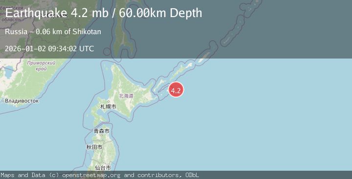
A 4.2 magnitude earthquake struck on KURIL ISLANDS, at Fri, 02 Jan 2026 09:34:02 GMT. Depth: 60km. Reviewed by GSRAS seismologists, this light quake occurred at a magnitude type of mb.
Magnitude
4.2
mb
Source
GSRAS
Intensity
-
Agency Reports
1 Sources| Source | Magnitude | Depth | Time |
|---|---|---|---|
| GSRASPrimary | 4.2 | 60 km | 1 month ago |
Earthquake Details
AutomaticEvent IDemsc_GSRAS_20260102_0000156
Tsunami PotentialNo
Magnitude Typemb
Nearest Places
- 41.9 km
- 42.0 km
- 42.2 km
- 42.6 km
- 43.0 km
Comments
Join the discussion about this event.
Latest Earthquakes
2.8Mag
Mendoza, Argentina
Time8 minutes ago
Depth181.76 km
SourceVYT (Automatic)
2.1Mag
Minahassa Peninsula, Sulawesi
Time19 minutes ago
Depth56.16 km
SourceBMKG
3.0Mag
NEAR EAST COAST OF HONSHU, JAPAN
Time25 minutes ago
Depth10.00 km
SourceJMA (Automatic)
0.8Mag
10 km NE of Julian, CA
Time27 minutes ago
Depth6.37 km
SourceUSGS (Automatic)
2.4Mag
Sulawesi, Indonesia
Time29 minutes ago
Depth18.80 km
SourceVYT (Automatic)
Nearby Earthquakes
5.3Mag
KURIL ISLANDS
Time14 years ago
Depth60.00 km
SourceEMSC (Automatic)
5.1Mag
KURIL ISLANDS
Time21 years ago
Depth60.00 km
SourceEMSC (Automatic)
5.7Mag
KURIL ISLANDS
Time17 years ago
Depth68.00 km
SourceEMSC (Automatic)
5.4Mag
KURIL ISLANDS
Time8 months ago
Depth63.00 km
SourceEMSC (Automatic)
4.0Mag
KURIL ISLANDS
Time2 years ago
Depth50.00 km
SourceGSRAS (Automatic)