Earthquake STRAIT OF GIBRALTAR
Thu, 22 Jan 2026 19:00:20 GMT
Time1 month ago
Location
36.7476, -2.9387
Depth
5.4 KM
Event Summary
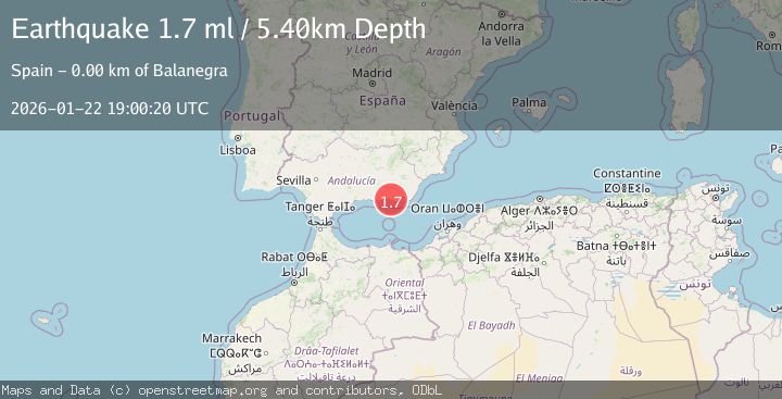
A 1.7 magnitude earthquake struck on STRAIT OF GIBRALTAR, at Thu, 22 Jan 2026 19:00:20 GMT. Depth: 5.4km. Reviewed by IGN seismologists, this minor quake occurred at a magnitude type of ml.
Magnitude
1.7
ml
Source
IGN
Intensity
-
Agency Reports
1 Sources| Source | Magnitude | Depth | Time |
|---|---|---|---|
| IGNPrimary | 1.7 | 5 km | 1 month ago |
Earthquake Details
AutomaticEvent IDemsc_IGN_20260122_0000355
Tsunami PotentialNo
Magnitude Typeml
Nearest Places
- 0.7 km
- 1.1 km
- 2.5 km
- 2.6 km
- 2.9 km
Comments
Join the discussion about this event.
Latest Earthquakes
3.4Mag
western Texas
Time1 minute ago
Depth0.00 km
SourceVYT (Automatic)
1.7Mag
Sumbawa region, Indonesia
Time2 minutes ago
Depth0.00 km
SourceVYT (Automatic)
2.1Mag
ISLAND OF HAWAII, HAWAII
Time17 minutes ago
Depth10.40 km
SourceHV (Automatic)
2.3Mag
Southeastern Alaska
Time17 minutes ago
Depth0.00 km
SourceVYT (Automatic)
3.1Mag
Southern Alaska
Time20 minutes ago
Depth61.04 km
SourceVYT (Automatic)
Nearby Earthquakes
1.8Mag
STRAIT OF GIBRALTAR
Time1 month ago
Depth9.40 km
SourceIGN (Automatic)
1.9Mag
STRAIT OF GIBRALTAR
Time2 months ago
Depth11.90 km
SourceIGN (Automatic)
3.0Mag
STRAIT OF GIBRALTAR
Time12 years ago
Depth10.00 km
SourceMDD (Automatic)
2.0Mag
STRAIT OF GIBRALTAR
Time1 month ago
Depth0.00 km
SourceIGN (Automatic)
1.5Mag
STRAIT OF GIBRALTAR
Time1 month ago
Depth7.50 km
SourceIGN (Automatic)