Earthquake DODECANESE IS.-TURKEY BORDER REG
Wed, 18 Feb 2026 03:56:49 GMT
Time6 hours ago
Location
36.8295, 28.3613
Depth
46.6 KM
Event Summary
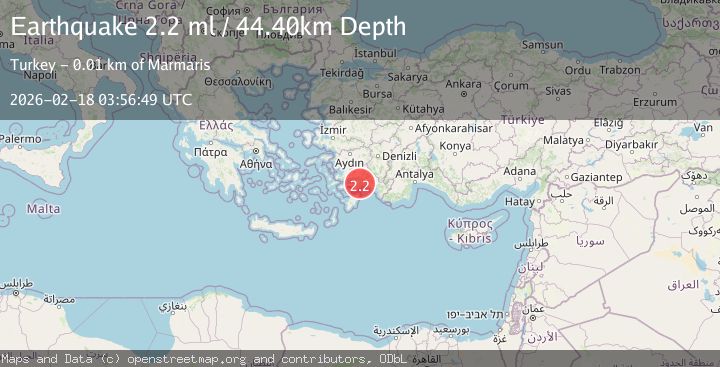
A 2.2 magnitude earthquake struck on DODECANESE IS.-TURKEY BORDER REG, at Wed, 18 Feb 2026 03:56:49 GMT. Depth: 46.6km. Reviewed by KOERI seismologists, this minor quake occurred at a magnitude type of ml.
Magnitude
2.2
ml
Source
KOERI
Intensity
-
Agency Reports
1 Sources| Source | Magnitude | Depth | Time |
|---|---|---|---|
| KOERIPrimary | 2.2 | 47 km | 6 hours ago |
Earthquake Details
AutomaticEvent IDemsc_KOERI_20260218_0000051
Tsunami PotentialNo
Magnitude Typeml
Nearest Places
- Sünger Tepesi1.4 km
- Aksaz Limani2.0 km
- Club Daystar2.5 km
- Dağardı Tepesi2.6 km
- Dağardı Deresi3.0 km
Comments
Join the discussion about this event.
Latest Earthquakes
3.5Mag
near the coast of Antofagasta, Chile
Time6 hours ago
Depth0.00 km
SourceVYT (Automatic)
1.7Mag
Southern California
Time6 hours ago
Depth0.00 km
SourceVYT (Automatic)
3.1Mag
northern Norway
Time6 hours ago
Depth707.40 km
SourceVYT (Automatic)
2.4Mag
Albania
Time6 hours ago
Depth14.77 km
SourceVYT (Automatic)
2.3Mag
WESTERN TURKEY
Time6 hours ago
Depth11.50 km
SourceKOERI (Automatic)
Nearby Earthquakes
3.0Mag
DODECANESE ISLANDS, GREECE
Time17 years ago
Depth5.00 km
SourceEMSC (Automatic)
3.0Mag
DODECANESE ISLANDS, GREECE
Time26 years ago
Depth10.00 km
SourceEMSC (Automatic)
3.0Mag
DODECANESE IS.-TURKEY BORDER REG
Time5 years ago
Depth58.00 km
SourceEMSC (Automatic)
3.0Mag
DODECANESE IS.-TURKEY BORDER REG
Time10 years ago
Depth65.00 km
SourceISK (Automatic)
3.0Mag
DODECANESE ISLANDS, GREECE
Time21 years ago
Depth28.00 km
SourceEMSC (Automatic)