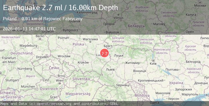
Earthquake POLAND-BELARUS-UKRAINE BORDER RG
Tue, 13 Jan 2026 14:47:01 GMT
Time1 month ago
Location
51.1900, 23.2000
Depth
16.0 KM
Event Summary
A 2.7 magnitude earthquake struck on POLAND-BELARUS-UKRAINE BORDER RG, at Tue, 13 Jan 2026 14:47:01 GMT. Depth: 16km. Reviewed by MCSM seismologists, this minor quake occurred at a magnitude type of ml.
Magnitude
2.7
ml
Source
MCSM
Intensity
-
Agency Reports
1 Sources| Source | Magnitude | Depth | Time |
|---|---|---|---|
| MCSMPrimary | 2.7 | 16 km | 1 month ago |
Earthquake Details
AutomaticEvent IDemsc_MCSM_20260113_0000382
Tsunami PotentialNo
Magnitude Typeml
Nearest Places
- 1.4 km
- 1.7 km
- 2.1 km
- 2.2 km
- 2.4 km
Comments
Join the discussion about this event.
Latest Earthquakes
1.0Mag
5 km WSW of Salton City, CA
Time7 minutes ago
Depth2.89 km
SourceUSGS (Automatic)
1.3Mag
Alaska Peninsula
Time11 minutes ago
Depth0.00 km
SourceVYT (Automatic)
1.3Mag
Southern Alaska
Time11 minutes ago
Depth40.04 km
SourceVYT (Automatic)
3.0Mag
Oruro, Bolivia
Time16 minutes ago
Depth208.50 km
SourceVYT (Automatic)
2.1Mag
Borneo
Time16 minutes ago
Depth5.00 km
SourceBMKG
Nearby Earthquakes
2.6Mag
POLAND-BELARUS-UKRAINE BORDER RG
Time1 month ago
Depth9.00 km
SourceMCSM (Automatic)
2.5Mag
POLAND-BELARUS-UKRAINE BORDER RG
Time1 month ago
Depth5.00 km
SourceMCSM (Automatic)
2.5Mag
POLAND-BELARUS-UKRAINE BORDER RG
Time1 month ago
Depth4.00 km
SourceMCSM (Automatic)
3.0Mag
POLAND
Time2 months ago
Depth10.00 km
SourceEMSC (Automatic)
3.0Mag
POLAND
Time1 month ago
Depth10.00 km
SourceMCSM (Automatic)