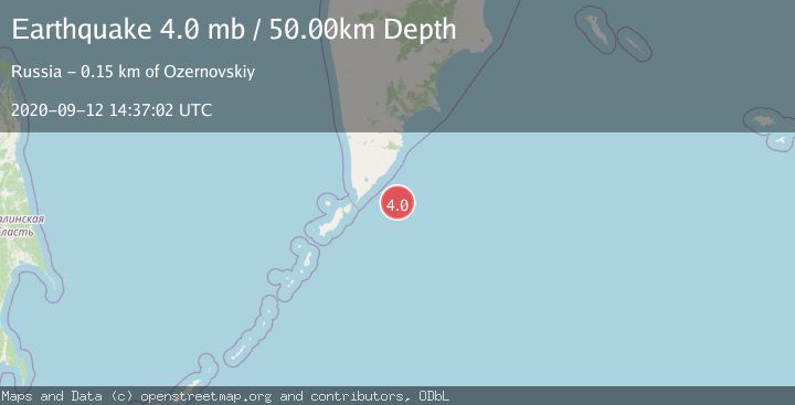
Earthquake EAST OF KURIL ISLANDS
Sat, 12 Sep 2020 14:37:02 GMT
Time5 years ago
Location
50.8900, 158.3600
Depth
50.0 KM
Event Summary
A 4.0 magnitude earthquake struck on EAST OF KURIL ISLANDS, at Sat, 12 Sep 2020 14:37:02 GMT. Depth: 50km. Reviewed by OBN seismologists, this light quake occurred at a magnitude type of mb.
Magnitude
4.0
mb
Source
OBN
Intensity
-
Agency Reports
1 Sources| Source | Magnitude | Depth | Time |
|---|---|---|---|
| OBNPrimary | 4.0 | 50 km | 5 years ago |
Earthquake Details
AutomaticEvent IDemsc_OBN_20200912_0000131
Tsunami PotentialNo
Magnitude Typemb
Nearest Places
- 79.8 km
- 82.1 km
- 82.1 km
- 82.6 km
- 82.8 km
Comments
Join the discussion about this event.
Latest Earthquakes
2.6Mag
Seram, Indonesia
Time9 minutes ago
Depth16.40 km
SourceBMKG
1.9Mag
NORTHERN ITALY
Time11 minutes ago
Depth12.00 km
SourceOGS (Automatic)
0.7Mag
13 km ESE of Julian, CA
Time17 minutes ago
Depth4.92 km
SourceUSGS (Automatic)
0.8Mag
6 km NW of The Geysers, CA
Time23 minutes ago
Depth2.94 km
SourceUSGS (Automatic)
2.4Mag
Minahassa Peninsula, Sulawesi
Time27 minutes ago
Depth166.04 km
SourceBMKG
Nearby Earthquakes
5.8Mag
EAST OF KURIL ISLANDS
Time6 months ago
Depth42.00 km
SourceEMSC (Automatic)
5.0Mag
NEAR EAST COAST OF KAMCHATKA
Time6 months ago
Depth47.00 km
SourceEMSC (Automatic)
5.2Mag
NEAR EAST COAST OF KAMCHATKA
Time6 months ago
Depth6.70 km
SourceEMSC (Automatic)
4.0Mag
EAST OF KURIL ISLANDS
Time5 years ago
Depth40.00 km
SourceOBN (Automatic)
5.1Mag
EAST OF KURIL ISLANDS
Time20 years ago
Depth50.00 km
SourceEMSC (Automatic)