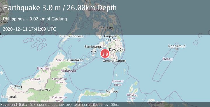
Earthquake MORO GULF, MINDANAO, PHILIPPINES
Fri, 11 Dec 2020 17:41:09 GMT
Time5 years ago
Location
6.8000, 123.8200
Depth
26.0 KM
Event Summary
A 3.0 magnitude earthquake struck on MORO GULF, MINDANAO, PHILIPPINES, at Fri, 11 Dec 2020 17:41:09 GMT. Depth: 26km. Reviewed by PIVS seismologists, this minor quake occurred at a magnitude type of m.
Magnitude
3.0
m
Source
PIVS
Intensity
-
Agency Reports
1 Sources| Source | Magnitude | Depth | Time |
|---|---|---|---|
| PIVSPrimary | 3.0 | 26 km | 5 years ago |
Earthquake Details
AutomaticEvent IDemsc_PIVS_20201211_0000132
Tsunami PotentialNo
Magnitude Typem
Nearest Places
- Ipil Point13.8 km
- Bamban Point14.6 km
- Huidobro Reef14.7 km
- Bamban Bay15.6 km
- Bral15.9 km
Comments
Join the discussion about this event.
Latest Earthquakes
2.3Mag
Poland
Time2 hours ago
Depth0.49 km
SourceVYT (Automatic)
1.7Mag
Java, Indonesia
Time2 hours ago
Depth5.98 km
SourceVYT (Automatic)
2.5Mag
SPAIN
Time2 hours ago
Depth2.90 km
SourceIGN (Automatic)
2.5Mag
West Papua Region, Indonesia
Time2 hours ago
Depth12.37 km
SourceBMKG
2.6Mag
Antofagasta, Chile
Time2 hours ago
Depth116.33 km
SourceVYT (Automatic)
Nearby Earthquakes
5.0Mag
MORO GULF, MINDANAO, PHILIPPINES
Time3 years ago
Depth60.00 km
SourceEMSC (Automatic)
5.0Mag
MORO GULF, MINDANAO, PHILIPPINES
Time13 years ago
Depth619.00 km
SourceEMSC (Automatic)
5.0Mag
MORO GULF, MINDANAO, PHILIPPINES
Time7 years ago
Depth10.00 km
SourceDJA (Automatic)
3.0Mag
MORO GULF, MINDANAO, PHILIPPINES
Time1 year ago
Depth32.00 km
SourcePIVS (Automatic)
3.0Mag
MORO GULF, MINDANAO, PHILIPPINES
Time2 years ago
Depth1.00 km
SourcePIVS (Automatic)