Earthquake PHILIPPINE ISLANDS REGION
Mon, 12 Jan 2026 20:06:14 GMT
Time1 month ago
Location
7.1400, 127.0100
Depth
13.0 KM
Event Summary
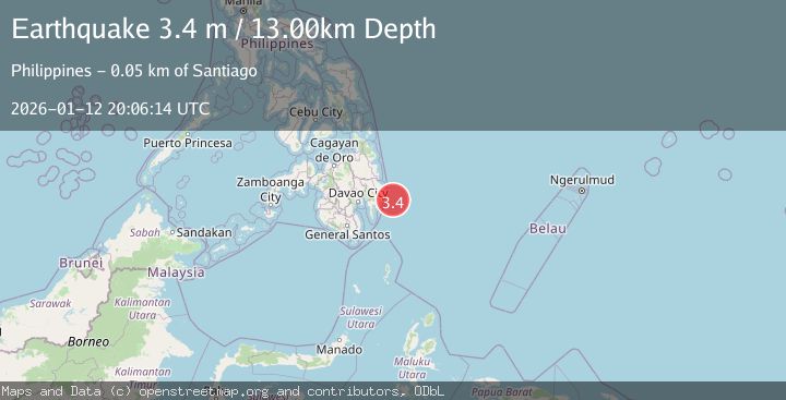
A 3.4 magnitude earthquake struck on PHILIPPINE ISLANDS REGION, at Mon, 12 Jan 2026 20:06:14 GMT. Depth: 13km. Reviewed by PIVS seismologists, this minor quake occurred at a magnitude type of m.
Magnitude
3.4
m
Source
PIVS
Intensity
-
Agency Reports
1 Sources| Source | Magnitude | Depth | Time |
|---|---|---|---|
| PIVSPrimary | 3.4 | 13 km | 1 month ago |
Earthquake Details
AutomaticEvent IDemsc_PIVS_20260112_0000312
Tsunami PotentialNo
Magnitude Typem
Nearest Places
- 47.9 km
- 49.1 km
- 49.3 km
- 49.7 km
- 49.9 km
Comments
Join the discussion about this event.
Latest Earthquakes
3.6Mag
Jujuy, Argentina
Time6 minutes ago
Depth200.56 km
SourceVYT (Automatic)
3.2Mag
South of Sumbawa, Indonesia
Time8 minutes ago
Depth10.00 km
SourceBMKG
2.6Mag
Poland
Time9 minutes ago
Depth1.59 km
SourceVYT (Automatic)
1.1Mag
WESTERN TURKEY
Time16 minutes ago
Depth7.00 km
SourceAFAD (Automatic)
1.4Mag
WESTERN TURKEY
Time18 minutes ago
Depth7.00 km
SourceAFAD (Automatic)
Nearby Earthquakes
3.0Mag
PHILIPPINE ISLANDS REGION
Time2 months ago
Depth17.00 km
SourcePIVS (Automatic)
3.0Mag
MINDANAO, PHILIPPINES
Time3 years ago
Depth28.00 km
SourcePIVS (Automatic)
5.2Mag
PHILIPPINE ISLANDS REGION
Time3 years ago
Depth10.00 km
SourceEMSC (Automatic)
3.0Mag
PHILIPPINE ISLANDS REGION
Time4 months ago
Depth14.00 km
SourcePIVS (Automatic)
3.0Mag
PHILIPPINE ISLANDS REGION
Time4 months ago
Depth5.00 km
SourcePIVS (Automatic)