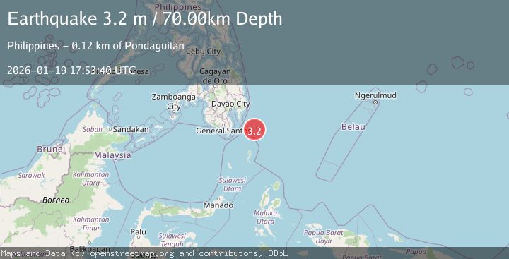
Earthquake PHILIPPINE ISLANDS REGION
Mon, 19 Jan 2026 17:53:40 GMT
Time1 month ago
Location
5.8300, 127.1000
Depth
70.0 KM
Event Summary
A 3.2 magnitude earthquake struck on PHILIPPINE ISLANDS REGION, at Mon, 19 Jan 2026 17:53:40 GMT. Depth: 70km. Reviewed by PIVS seismologists, this minor quake occurred at a magnitude type of m.
Magnitude
3.2
m
Source
PIVS
Intensity
-
Agency Reports
1 Sources| Source | Magnitude | Depth | Time |
|---|---|---|---|
| PIVSPrimary | 3.2 | 70 km | 1 month ago |
Earthquake Details
AutomaticEvent IDemsc_PIVS_20260119_0000245
Tsunami PotentialNo
Magnitude Typem
Nearest Places
- Tanjung Dapapa63.7 km
- Desa Pulau Miangas64.7 km
- Pulau Miangas64.7 km
- Kecamatan Miangas64.7 km
- Miangas65.4 km
Comments
Join the discussion about this event.
Latest Earthquakes
1.9Mag
Finland
Time3 minutes ago
Depth1.22 km
SourceVYT (Automatic)
1.3Mag
Southern Alaska
Time3 minutes ago
Depth16.36 km
SourceVYT (Automatic)
0.7Mag
7 km W of Cobb, CA
Time3 minutes ago
Depth2.05 km
SourceUSGS (Automatic)
2.2Mag
Tarapaca, Chile
Time7 minutes ago
Depth16.97 km
SourceVYT (Automatic)
1.8Mag
24 km ESE of Naalehu, Hawaii
Time10 minutes ago
Depth31.03 km
SourceUSGS (Automatic)
Nearby Earthquakes
5.0Mag
PHILIPPINE ISLANDS REGION
Time16 years ago
Depth30.00 km
SourceEMSC (Automatic)
3.0Mag
PHILIPPINE ISLANDS REGION
Time1 year ago
Depth37.00 km
SourcePIVS (Automatic)
5.0Mag
PHILIPPINE ISLANDS REGION
Time11 years ago
Depth106.00 km
SourceEMSC (Automatic)
3.0Mag
PHILIPPINE ISLANDS REGION
Time5 years ago
Depth80.00 km
SourcePIVS (Automatic)
5.7Mag
PHILIPPINE ISLANDS REGION
Time11 years ago
Depth100.00 km
SourceEMSC (Automatic)