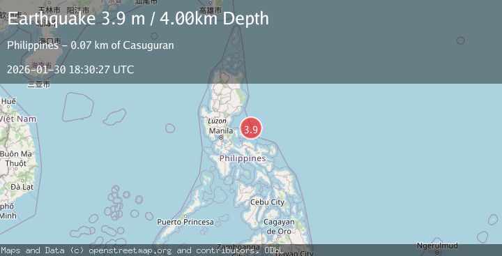
Earthquake PHILIPPINE ISLANDS REGION
Fri, 30 Jan 2026 18:30:27 GMT
Time2 months ago
Location
15.1600, 122.8900
Depth
4.0 KM
Event Summary
A 3.9 magnitude earthquake struck on PHILIPPINE ISLANDS REGION, at Fri, 30 Jan 2026 18:30:27 GMT. Depth: 4km. Reviewed by PIVS seismologists, this minor quake occurred at a magnitude type of m.
Magnitude
3.9
m
Source
PIVS
Intensity
I
Agency Reports
2 Sources| Source | Magnitude | Depth | Time |
|---|---|---|---|
| PIVSPrimary | 3.9 | 4 km | 2 months ago |
| NEIC | 3.9 | 10 km | 2 months ago |
Earthquake Details
AutomaticEvent IDemsc_PIVS_20260130_0000319
QualityS
Tsunami PotentialNo
Magnitude Typem
Last Update1 month ago
Nearest Places
Possibly felt by: 20.9K
- 74.2 km2.3K people
- 86.7 km6.9K people
- 93.3 km2.6K people
- 94.8 km4.3K people
- 96.2 km2.3K people
- 98.4 km8.3K people
- 99.0 km21.2K people
- 99.2 km4.3K people
- 100.5 km3.8K people
- 101.2 km4K people
- 101.6 km3.9K people
- 101.8 km2.3K people
- 104.1 km5K people
- 104.2 km2.4K people
- 104.4 km4.7K people
- 104.6 km2.8K people
- 105.0 km4.5K people
- 107.5 km2.7K people
- 109.3 km3.5K people
- 109.3 km3.4K people
- 109.7 km13.6K people
- 111.6 km2.9K people
- ILabo112.1 km18.1K people
- 112.4 km3.6K people
- 112.5 km5.5K people
- 113.1 km3K people
- 114.1 km7.5K people
- 114.1 km3.5K people
- 115.6 km2.2K people
- IDaet116.7 km78.1K people
- 116.9 km2.3K people
- 117.2 km4.5K people
- 117.3 km2.8K people
- 117.5 km17K people
- 117.6 km2.1K people
- 118.0 km2.8K people
- 119.1 km5.7K people
- 119.8 km2.4K people
- 121.7 km2.8K people
- 122.0 km5.2K people
Felt Reports0
Did you feel this earthquake? Report it to help others.
No reports yet
Be the first to report this earthquake!
Latest Earthquakes
Loading...
Nearby Earthquakes
3.0Mag
PHILIPPINE ISLANDS REGION
Time1 day ago
Depth4.00 km
SourcePIVS (Automatic)
3.0Mag
PHILIPPINE ISLANDS REGION
Time1 day ago
Depth2.00 km
SourcePIVS (Automatic)
3.2Mag
PHILIPPINE ISLANDS REGION
Time1 day ago
Depth10.00 km
SourcePIVS (Automatic)
3.1Mag
PHILIPPINE ISLANDS REGION
Time1 day ago
Depth4.00 km
SourcePIVS (Automatic)
3.6Mag
PHILIPPINE ISLANDS REGION
Time3 days ago
Depth10.00 km
SourcePIVS (Automatic)