Earthquake PHILIPPINE ISLANDS REGION
Fri, 13 Feb 2026 20:11:15 GMT
Time6 days ago
Location
10.1300, 126.5400
Depth
33.0 KM
Event Summary
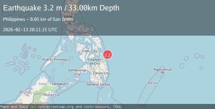
A 3.2 magnitude earthquake struck on PHILIPPINE ISLANDS REGION, at Fri, 13 Feb 2026 20:11:15 GMT. Depth: 33km. Reviewed by PIVS seismologists, this minor quake occurred at a magnitude type of m.
Magnitude
3.2
m
Source
PIVS
Intensity
-
Agency Reports
1 Sources| Source | Magnitude | Depth | Time |
|---|---|---|---|
| PIVSPrimary | 3.2 | 33 km | 6 days ago |
Earthquake Details
AutomaticEvent IDemsc_PIVS_20260213_0000306
Tsunami PotentialNo
Magnitude Typem
Nearest Places
- Arena Point51.6 km
- Arena Point52.0 km
- Buhing Calipay52.0 km
- Alegria52.2 km
- Baybay52.3 km
Comments
Join the discussion about this event.
Latest Earthquakes
2.1Mag
Sumbawa Region, Indonesia
Time4 minutes ago
Depth123.07 km
SourceBMKG
1.0Mag
8 km WNW of The Geysers, CA
Time6 minutes ago
Depth0.69 km
SourceUSGS (Automatic)
2.3Mag
SAN FRANCISCO BAY AREA, CALIF.
Time9 minutes ago
Depth8.70 km
SourceNC (Automatic)
2.1Mag
WESTERN TEXAS
Time11 minutes ago
Depth0.00 km
SourceTX (Automatic)
1.9Mag
Tarapaca, Chile
Time15 minutes ago
Depth0.00 km
SourceVYT (Automatic)
Nearby Earthquakes
5.0Mag
PHILIPPINE ISLANDS REGION
Time4 years ago
Depth37.00 km
SourceEMSC (Automatic)
4.0Mag
PHILIPPINE ISLANDS REGION
Time4 years ago
Depth7.00 km
SourcePIVS (Automatic)
4.0Mag
PHILIPPINE ISLANDS REGION
Time8 months ago
Depth10.00 km
SourcePIVS (Automatic)
3.0Mag
PHILIPPINE ISLANDS REGION
Time5 years ago
Depth5.00 km
SourcePIVS (Automatic)
5.0Mag
PHILIPPINE ISLANDS REGION
Time11 years ago
Depth10.00 km
SourceEMSC (Automatic)