Earthquake PERU-ECUADOR BORDER REGION
Mon, 01 Feb 2021 18:03:06 GMT
Time5 years ago
Location
-3.0000, -80.9400
Depth
2.0 KM
Event Summary
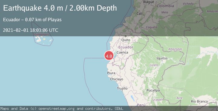
A 4.0 magnitude earthquake struck on PERU-ECUADOR BORDER REGION, at Mon, 01 Feb 2021 18:03:06 GMT. Depth: 2km. Reviewed by QUI seismologists, this light quake occurred at a magnitude type of m.
Magnitude
4.0
m
Source
QUI
Intensity
-
Agency Reports
1 Sources| Source | Magnitude | Depth | Time |
|---|---|---|---|
| QUIPrimary | 4.0 | 2 km | 5 years ago |
Earthquake Details
AutomaticEvent IDemsc_QUI_20210201_0000219
Tsunami PotentialNo
Magnitude Typem
Nearest Places
- Golfo de Guayaquil48.9 km
- Bajo del Muerto57.6 km
- Punta Pico58.8 km
- Isla Santa Clara59.1 km
- Isla Santa Clara Lighthouse59.2 km
Comments
Join the discussion about this event.
Latest Earthquakes
2.5Mag
San Juan, Argentina
Time6 minutes ago
Depth363.53 km
SourceVYT (Automatic)
2.4Mag
Java, Indonesia
Time6 minutes ago
Depth102.46 km
SourceBMKG
3.9Mag
Halmahera, Indonesia
Time8 minutes ago
Depth161.01 km
SourceVYT (Automatic)
1.0Mag
3 km W of Cobb, CA
Time9 minutes ago
Depth2.45 km
SourceUSGS (Automatic)
4.4Mag
NEAR EAST COAST OF HONSHU, JAPAN
Time11 minutes ago
Depth30.00 km
SourceJMA (Automatic)
Nearby Earthquakes
6.0Mag
NEAR COAST OF NORTHERN PERU
Time20 years ago
Depth10.00 km
SourceEMSC (Automatic)
3.0Mag
NEAR COAST OF ECUADOR
Time5 years ago
Depth26.00 km
SourceQUI (Automatic)
5.1Mag
NEAR COAST OF NORTHERN PERU
Time20 years ago
Depth2.00 km
SourceEMSC (Automatic)
5.0Mag
NEAR COAST OF ECUADOR
Time12 years ago
Depth40.00 km
SourceEMSC (Automatic)
4.0Mag
PERU-ECUADOR BORDER REGION
Time2 years ago
Depth10.00 km
SourceQUI (Automatic)