Earthquake PERU-ECUADOR BORDER REGION
Sat, 17 Feb 2024 03:45:17 GMT
Time2 years ago
Location
-4.9700, -79.1900
Depth
5.0 KM
Event Summary
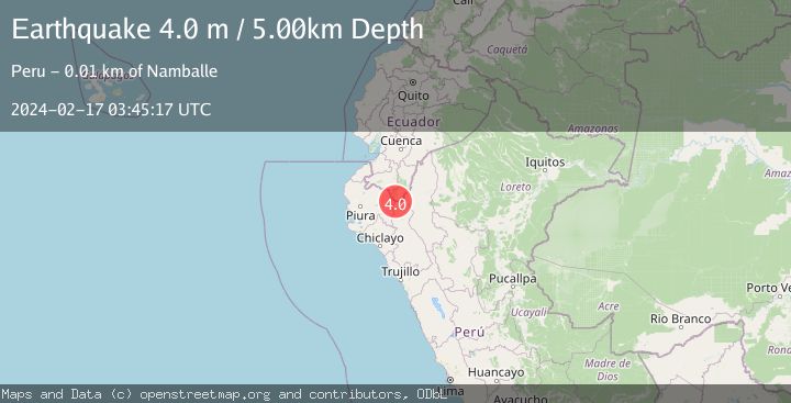
A 4.0 magnitude earthquake struck on PERU-ECUADOR BORDER REGION, at Sat, 17 Feb 2024 03:45:17 GMT. Depth: 5km. Reviewed by QUI seismologists, this light quake occurred at a magnitude type of m.
Magnitude
4.0
m
Source
QUI
Intensity
IV
Agency Reports
1 Sources| Source | Magnitude | Depth | Time |
|---|---|---|---|
| QUIPrimary | 4.0 | 5 km | 2 years ago |
Earthquake Details
AutomaticEvent IDemsc_QUI_20240217_0000043
QualityS
Tsunami PotentialNo
Magnitude Typem
Last Update2 months ago
Nearest Places
Possibly felt by: 61.8K
- IVNamballe11.8 km
- IIISan Ignacio28.6 km7.9K people
- IIISapalache33.8 km487 people
- IIITabaconas39.7 km443 people
- IIIHuancabamba41.5 km8.6K people
- IIISondor45.5 km987 people
- 48.8 km311 people
- IIChirinos49.3 km
- 53.0 km
- IITunal60.5 km568 people
- IILa Coipa63.0 km
- 64.8 km871 people
- IIYamango66.4 km973 people
- IIChalaco67.3 km
- IIAyabaca68.8 km5.3K people
- IILagunas75.2 km246 people
- IIHuarmaca75.8 km
- 76.0 km
- IISallique77.7 km894 people
- IIHuabal77.9 km732 people
- 78.7 km301 people
- IIJilili79.9 km351 people
- IIMontero80.2 km
- 82.0 km778 people
- 82.1 km16.9K people
- 84.1 km
- 89.7 km382 people
- 89.8 km12.3K people
- 90.3 km821 people
- 91.6 km7.9K people
- 91.9 km
- IJaén92.3 km52.5K people
- 95.8 km6.3K people
- 97.2 km
- 102.0 km
- ISuyo103.3 km985 people
- 103.5 km5.8K people
- 103.5 km
- 103.8 km15.3K people
- 106.1 km13K people
- 106.7 km
- 107.5 km
- 108.6 km68.8K people
- ILoja108.6 km274.1K people
- 109.9 km27K people
- 111.0 km18.6K people
- 113.0 km975 people
- 113.1 km12.5K people
- 114.3 km10.9K people
- 117.2 km367 people
- 119.8 km323 people
- 120.1 km7.3K people
- 120.5 km20.4K people
- 120.6 km
- 122.0 km
- 122.3 km9.4K people
- 128.0 km30K people
- 128.5 km9.8K people
- 128.5 km5.5K people
Felt Reports0
Did you feel this earthquake? Report it to help others.
No reports yet
Be the first to report this earthquake!
Latest Earthquakes
Loading...
Nearby Earthquakes
4.2Mag
NORTHERN PERU
Time3 weeks ago
Depth22.00 km
SourceLIM (Automatic)
3.5Mag
NORTHERN PERU
Time1 month ago
Depth23.00 km
SourceLIM (Automatic)
3.5Mag
NORTHERN PERU
Time1 month ago
Depth24.00 km
SourceLIM (Automatic)
4.1Mag
NORTHERN PERU
Time1 month ago
Depth15.00 km
SourceLIM (Automatic)
4.8Mag
NORTHERN PERU
Time1 month ago
Depth10.00 km
SourceGFZ (Automatic)