Earthquake 49 km WNW of Petrolia, CA
Sat, 11 Jan 2025 12:12:40 GMT
Time11 months ago
Location
40.3555, -124.8598
Depth
-0.1 KM
Event Summary
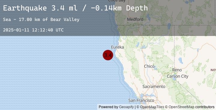
A 3.4 magnitude earthquake struck on 49 km WNW of Petrolia, CA, at Sat, 11 Jan 2025 12:12:40 GMT. Depth: -0.140000000596046km. Reviewed by USGS seismologists, this minor quake occurred at a magnitude type of ml.
Magnitude
3.4
ml
Source
USGS
Intensity
-
Earthquake Details
AutomaticEvent IDusgs_nc75115866
Tsunami PotentialNo
Magnitude Typeml
Nearest Places
- Bear Valley17.0 km
- Mendocino Canyon21.4 km
- Gorda Escarpment26.0 km
- Blunts Reef Coast Guard Station31.7 km
- Blunts Reef Lightship (historical)32.2 km
Comments
Join the discussion about this event.
Latest Earthquakes
1.8Mag
62 km WSW of Cantwell, Alaska
Time4 minutes ago
Depth82.70 km
SourceUSGS (Automatic)
1.9Mag
38 km SSE of Naalehu, Hawaii
Time7 minutes ago
Depth6.40 km
SourceUSGS (Automatic)
2.3Mag
West Papua Region, Indonesia
Time12 minutes ago
Depth10.00 km
SourceBMKG (Automatic)
1.5Mag
54 km ESE of Denali Park, Alaska
Time14 minutes ago
Depth2.80 km
SourceUSGS (Automatic)
3.3Mag
NEAR COAST OF NICARAGUA
Time19 minutes ago
Depth64.00 km
SourceINET (Automatic)
Nearby Earthquakes
No significant earthquakes nearby recently.