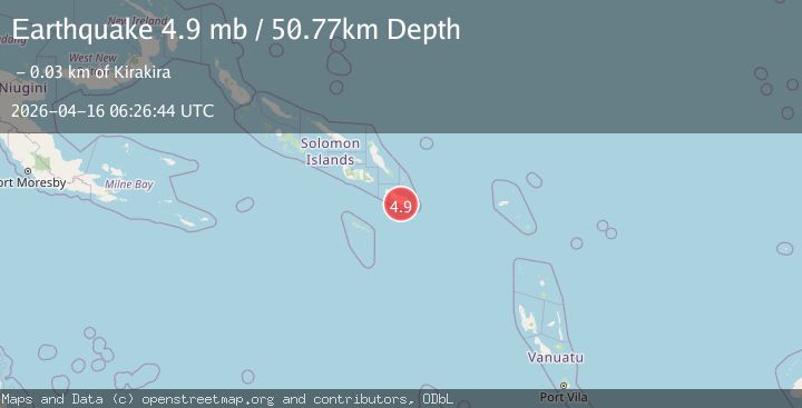
Earthquake 33 km S of Kirakira, Solomon Islands
Thu, 16 Apr 2026 06:26:44 GMT
Time3 months ago
Location
-10.7563, 161.9355
Depth
50.8 KM
Event Summary
A 4.9 magnitude earthquake struck on 33 km S of Kirakira, Solomon Islands, at Thu, 16 Apr 2026 06:26:44 GMT. Depth: 50.768km. Reviewed by USGS seismologists, this light quake occurred at a magnitude type of mb.
Magnitude
4.9
mb
Source
USGS
Intensity
III
Agency Reports
3 Sources| Source | Magnitude | Depth | Time |
|---|---|---|---|
| USGSPrimary | 4.9 | 51 km | 3 months ago |
| EMSC | 5.0 | 56 km | 3 months ago+2s |
| GSRAS | 5.1 | 50 km | 3 months ago+10s |
Earthquake Details
ConfirmedEvent IDusgs_us6000sqhl
QualityS
Tsunami PotentialNo
Magnitude Typemb
Last Update3 months ago
Used Stations31
Felt Reports0
Did you feel this earthquake? Report it to help others.
No reports yet
Be the first to report this earthquake!
Latest Earthquakes
Loading...
Nearby Earthquakes
5.2Mag
SOLOMON ISLANDS
Time0 months ago
Depth61.00 km
SourceEMSC (Automatic)
5.1Mag
100 km E of Kirakira, Solomon Islands
Time0 months ago
Depth10.00 km
SourceUSGS
4.6Mag
SOLOMON ISLANDS
Time1 month ago
Depth79.70 km
SourceNEIC (Automatic)
4.1Mag
SOLOMON ISLANDS
Time1 month ago
Depth96.80 km
SourceNEIC (Automatic)
4.5Mag
SOLOMON ISLANDS
Time2 months ago
Depth10.00 km
SourceNEIC (Automatic)