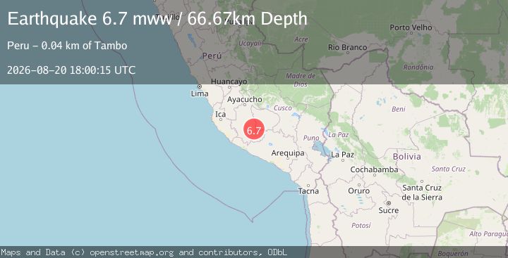
Earthquake 38 km NW of Upahuacho, Peru
Thu, 20 Aug 2026 18:00:15 GMT
Time2 months ago
Location
-14.6262, -73.6160
Depth
66.7 KM
Event Summary
A 6.7 magnitude earthquake struck on 38 km NW of Upahuacho, Peru, at Thu, 20 Aug 2026 18:00:15 GMT. Depth: 66.665km. Reviewed by USGS seismologists, this strong quake occurred at a magnitude type of mww.
Magnitude
6.7
mww
Source
USGS
Intensity
VI
Agency Reports
2 Sources| Source | Magnitude | Depth | Time |
|---|---|---|---|
| USGSPrimary | 6.7 | 67 km | 2 months ago |
| EMSC | 6.7 | 70 km | 2 months ago+1s |
Earthquake Details
ConfirmedEvent IDusgs_us6000tm81
QualityS
Tsunami PotentialNo
Magnitude Typemww
Last Update2 months ago
Used Stations123
Nearest Places
Possibly felt by: 5.4M
- VITambo38.3 km5K people
- 38.4 km191 people
- VIChipao40.3 km
- VIAniso40.4 km195 people
- 44.7 km520 people
- 45.6 km
- VIChaviña46.1 km
- 48.7 km7.4K people
- 49.4 km690 people
- 50.0 km539 people
- 53.1 km
- 54.1 km517 people
- 54.6 km
- 55.0 km
- 55.1 km550 people
- 55.1 km
- 56.2 km630 people
- 56.3 km10.5K people
- 56.9 km
- 58.1 km395 people
- 60.4 km691 people
- 61.0 km147 people
- 63.2 km712 people
- 63.8 km511 people
- 64.0 km730 people
- 64.0 km539 people
- 64.8 km276 people
- 65.3 km442 people
- 65.5 km472 people
- 66.3 km648 people
- 66.4 km178 people
- 68.3 km
- 68.4 km353 people
- 68.8 km567 people
- 69.0 km324 people
- 69.5 km776 people
- 71.0 km178 people
- 71.1 km662 people
- 72.3 km
- 72.5 km550 people
- 72.8 km332 people
- 74.0 km693 people
- 74.3 km278 people
- 75.9 km342 people
- 76.1 km898 people
- 76.8 km622 people
- 78.3 km
- 78.6 km723 people
- 78.6 km560 people
- 79.2 km532 people
- 80.2 km737 people
- 83.6 km303 people
- 83.9 km962 people
- 84.3 km
- 84.6 km566 people
- 85.0 km
- 86.2 km119 people
- 87.5 km740 people
- 87.8 km253 people
- 90.0 km367 people
- 91.0 km182 people
- 93.7 km343 people
- 94.7 km739 people
- 96.2 km59 people
- 96.9 km639 people
- 96.9 km409 people
- 98.3 km219 people
- 98.9 km252 people
- 100.0 km500 people
- 100.8 km919 people
- 101.8 km
- VToro102.4 km364 people
- 102.4 km247 people
- 103.2 km433 people
- 103.3 km128 people
- 104.0 km357 people
- 104.7 km326 people
- 106.8 km977 people
- VAlca107.5 km481 people
- 108.2 km
- 110.1 km7.4K people
- 110.4 km676 people
- 110.7 km17.4K people
- 111.2 km714 people
- 111.8 km5.6K people
- 112.8 km312 people
- 113.2 km243 people
- 113.7 km529 people
- 114.0 km338 people
- 114.0 km
- 115.7 km560 people
- 115.8 km243 people
- 115.8 km603 people
- 116.2 km923 people
- 116.6 km331 people
- 116.9 km
- 117.0 km857 people
- 118.4 km314 people
- 118.9 km663 people
- 119.7 km424 people
- 121.4 km
- 121.5 km
- 121.8 km
- 121.9 km537 people
- 122.4 km518 people
- 122.5 km736 people
- 122.9 km991 people
- 123.1 km
- 123.7 km
- 124.0 km650 people
- 124.7 km
- 125.3 km427 people
- 125.7 km91 people
- 126.0 km373 people
- 126.9 km185 people
- IVOcobamba127.3 km772 people
- IVSarhua130.3 km
- 131.8 km437 people
- IVOcaña132.3 km572 people
- 134.1 km
- 135.8 km
- IVAbancay135.8 km72.3K people
- IVOngoy136.1 km230 people
- IVAchanizo136.5 km352 people
- IVProgreso137.3 km708 people
- IVHuaccana137.9 km887 people
- IVTamburco138.0 km
- IVAcarí139.1 km4.4K people
- IVChuschi140.2 km
- IVLaramate141.0 km
- IVOcros141.1 km592 people
- IVNazca144.1 km23.6K people
- 144.5 km515 people
- IVLlauta145.7 km267 people
- 146.1 km910 people
- 146.4 km423 people
- 149.9 km388 people
- 150.4 km554 people
- IVYauca151.0 km
- IVCachora151.1 km805 people
- IVAtiquipa152.8 km137 people
- IVTotos153.1 km
- IVAndaray153.3 km351 people
- IVChala153.6 km
- 154.3 km5.6K people
- 155.0 km
- IVIquipi155.1 km362 people
- 155.2 km
- 155.2 km427 people
- IVChungui156.1 km551 people
- 157.7 km
- IVPampas158.3 km127 people
- IVHaquira160.3 km
- IVQuiñota162.8 km726 people
- IVAcocro163.1 km543 people
- IVUrasqui163.1 km223 people
- IVChiara163.4 km328 people
- IVViraco163.8 km
- 164.6 km
- IVLlusco164.8 km967 people
- IVChilcas164.8 km252 people
- 166.1 km4.1K people
- IVOcoyo166.3 km212 people
- 167.3 km
- IVTambillo168.2 km192 people
- IVPalpa169.2 km5.9K people
- 169.8 km
- 170.8 km4.7K people
- IVLlipata171.4 km336 people
- IVCayarani171.6 km457 people
- IVSocos173.0 km758 people
- 173.0 km247 people
- 173.1 km
- IVMara173.2 km
- IVIray173.2 km305 people
- 173.3 km15.5K people
- IVVinchos173.3 km669 people
- 173.5 km
- 173.8 km
- IVAyacucho175.8 km140K people
- 176.0 km14.3K people
- IVAtico176.1 km199 people
- IVUñon176.8 km263 people
- IVTibillo177.8 km178 people
- 179.7 km
- IVTicllas183.2 km169 people
- 183.7 km8.4K people
- IVQuinua184.2 km
- IVSan Juan185.3 km12.8K people
- IVAyo185.8 km262 people
- 185.8 km943 people
- 186.0 km466 people
- IVCcapi186.5 km862 people
- IVVelille186.7 km
- 187.1 km624 people
- 189.6 km
- IVChoco191.3 km219 people
- 192.5 km555 people
- 192.7 km
- IVTambo193.2 km
- IVChamaca193.2 km689 people
- 193.3 km466 people
- IVZurite196.2 km
- 199.6 km
- 200.3 km816 people
- IVHuanta200.3 km18.6K people
- IVAplao201.1 km
- IVChincho201.6 km83 people
- 201.6 km4.4K people
- 201.8 km
- IVHuambo203.1 km530 people
- 203.3 km
- 203.4 km734 people
- IVCcorca203.9 km
- IVAnta203.9 km5.9K people
- 204.3 km
- IVAccha206.0 km
- IVPucyura206.4 km
- 207.7 km
- 207.8 km673 people
- IVOcoña208.2 km
- IVTapay208.8 km121 people
- 209.6 km
- 210.0 km
- IVLivitaca210.3 km948 people
- IVMarcas210.8 km680 people
- 210.9 km2K people
- IVPoroy211.1 km961 people
- IVOmacha211.3 km398 people
- IVMaranura211.5 km730 people
- 211.6 km492 people
- IVMaras213.1 km
- IVParuro213.2 km
- 213.3 km587 people
- IVColcha213.5 km194 people
- IVSantiago214.3 km64.1K people
- IVCaja214.5 km
- IVAcos215.8 km759 people
- IVCorire215.9 km
- IVCusco216.1 km428.4K people
- 216.1 km4.7K people
- IVWanchaq216.1 km59.1K people
- IVLircay216.4 km
- 217.8 km
- 218.4 km25.1K people
- IVUrubamba218.6 km7.5K people
- 218.8 km250 people
- IVMayocc219.2 km711 people
- 219.9 km
- IVYucay220.1 km
- 220.2 km408 people
- 220.3 km
- IVAcobamba221.0 km
- 221.5 km
- IVAyna222.1 km4.6K people
- IVMadrigal222.7 km690 people
- IVAcomayo222.9 km
- IVOcucaje223.2 km
- 223.7 km652 people
- IVKimbiri223.9 km4.4K people
- IVSaylla224.4 km
- 224.9 km265 people
- 226.3 km
- IVAnchonga226.4 km280 people
- IVLari227.1 km
- IVMaca228.2 km908 people
- 228.4 km892 people
- IVOropesa229.7 km4K people
- 229.9 km5.2K people
- IIICalca230.2 km9.2K people
- IIILamay230.3 km
- IIIChurcampa230.3 km
- IIIPomacanchi230.6 km
- IIILucre230.6 km
- IIICoya230.7 km
- IIISantiago230.9 km10.4K people
- IIITaray231.0 km489 people
- IIILluta231.0 km6K people
- IIILos Aquijes231.1 km7.8K people
- IIIPueblo Nuevo231.9 km
- IIIPisac233.1 km2K people
- IIILocroja233.4 km
- IIICahuanuyo233.9 km3.9K people
- IIILa Tinguiña233.9 km
- 234.2 km
- IIIQuehue234.2 km257 people
- IIISan Salvador235.2 km
- IIIAchoma235.6 km
- IIIIca235.9 km282.4K people
- IIITungasuca236.1 km3.8K people
- IIIIchupampa236.3 km710 people
- 236.4 km4.1K people
- IIIEcharate236.4 km
- IIICaicay236.6 km333 people
- IIIPichigua236.7 km266 people
- IIIPichari237.4 km
- IIIHuaro237.6 km
- IIIMosoc Llacta237.6 km3.8K people
- IIIChignayhua237.6 km3.9K people
- 237.8 km
- IIIFonavi237.8 km6.7K people
- IIIYauri238.0 km23.9K people
- IIIPampamarca238.3 km3.8K people
- 238.4 km6.9K people
- IIICoporaque239.0 km
- IIIUrcos239.0 km5.5K people
- IIIYanque239.0 km
- IIIEl Cardo239.5 km744 people
- IIIYanaoca239.6 km3.9K people
- IIILares239.7 km522 people
- IIIChecca239.8 km3.8K people
- IIISanta Ana239.9 km78 people
- IIISubtanjalla240.5 km9.1K people
- IIITicrapo240.6 km
- IIIQuiquijana241.0 km
- IIICusipata241.8 km
- IIILa Pampa241.9 km
- IIICocas242.0 km158 people
- IIICamaná242.4 km16.4K people
- IIIChecacupe242.4 km3.4K people
- IIIMollepampa242.5 km141 people
- IIICombapata242.7 km3.5K people
- IIIGuadalupe243.1 km
- IIITuti243.7 km747 people
- IIIChivay243.8 km4.5K people
- IIICcuntuma243.8 km3.5K people
- IIITinta243.9 km3.5K people
- IIIHuancano244.1 km355 people
- IIIQueromarca245.4 km3.5K people
- IIILa Esmeralda245.8 km
- IIIEl Pedregal246.1 km20.1K people
- IIITisco246.3 km199 people
- IIICcolo248.2 km3.9K people
- IIIQquea248.5 km3.5K people
- IIIPitumarca248.6 km
- IIICcatca248.8 km538 people
- IIIEl Descanso248.8 km
- IIIQuellouno248.9 km
- IIISan Pedro249.8 km
- IIIPaucarbamba250.7 km786 people
- IIISibayo250.8 km527 people
- IIIHuancavelica252.0 km49.6K people
- IIISan Pablo252.2 km3.5K people
- IIIJayobamba252.3 km3.6K people
- IIIAscencion252.3 km9.1K people
- IIIColquepata252.5 km559 people
- IIILima Pampa252.7 km3.6K people
- IIICallalli252.8 km
- IIILangui253.1 km4K people
- IIICullcuyre253.2 km3.6K people
- IIIAccocunca254.5 km247 people
- 255.1 km
- IIIHuachos259.4 km754 people
- IIISicuani260.4 km33.6K people
- IIIConchopata260.8 km4K people
- IIIAcoria262.1 km
- IIIPaucartambo262.4 km
- IIIChallabamba263.9 km875 people
- IIIHuarancante263.9 km4.6K people
- IIIQuilca264.4 km207 people
- IIIHumay264.6 km662 people
- 264.6 km4K people
- IIIOcongate265.0 km
- IIIMaranganí265.1 km3.7K people
- IIILayo265.3 km4K people
- IIIArma266.5 km284 people
- IIIJayune269.3 km4.3K people
- IIISan Juan270.8 km146 people
- IIICallanca271.1 km4K people
- IIIOcoruro271.5 km158 people
- IIILlongasora273.0 km4.8K people
- 273.7 km4.4K people
- IIIColcabamba273.9 km
- 274.2 km4.3K people
- IIIMosoc Cancha274.9 km4.5K people
- IIIYura275.2 km5.7K people
- IIIPucara275.9 km4.3K people
- IIIChupamarca277.9 km274 people
- IIIHuamatambo279.2 km174 people
- IIIIzcuchaca279.4 km580 people
- 280.2 km
- 280.6 km6.4K people
- IIICondoroma280.6 km
- IIIPampas282.3 km5.5K people
- IIICono Norte283.9 km14.5K people
- IIIPangoa286.9 km6.6K people
- IIICuenca288.0 km422 people
- IIICono Norte288.4 km47.3K people
- IIIUchumayo288.8 km
- IIIVizcachane290.6 km4.4K people
- IIIAcobambilla291.1 km
- IIITupac Amaru291.5 km11.2K people
- IIIEl Carmen291.7 km
- IIIMacari292.3 km
- IIIVilca292.4 km293 people
- IIISan Clemente293.3 km15.8K people
- IIIPilchaca295.0 km413 people
- IIICerro Verde295.1 km3.6K people
- IIIOcuviri295.6 km823 people
- IIILlalli295.8 km
- IIISelva Alegre296.2 km72.7K people
- 296.5 km4.4K people
- IIITiabaya297.0 km
- IIIPisco297.2 km61.9K people
- IIICupi297.3 km317 people
- IIIArequipa297.6 km1M people
- IIIHuaribamba297.7 km787 people
- IIISalcabamba297.9 km208 people
- IIIParacas297.9 km1.2K people
- IIIMadean299.0 km258 people
- IIIHuayllahuara299.1 km581 people
- 299.2 km46.1K people
- IIIViñac300.1 km266 people
- 300.2 km
- IIISurcubamba300.3 km
- 300.4 km76.4K people
- IIILincha300.5 km198 people
- IIIChincha Alta303.3 km153.1K people
- IIISocabaya303.5 km
- IIIChincha Baja303.9 km
- IIISanta Rosa304.5 km
- IIISabandia305.4 km
- IIISunampe305.5 km
- IIISan Pedro306.4 km
- 306.7 km8.4K people
- IIICharacato306.7 km
- IIIHuangascar306.7 km309 people
- IIIMarcapata307.5 km
- IIIPazos307.6 km
- IIIHongos307.6 km371 people
- IIIChocos308.4 km328 people
- IIIChiguata308.7 km464 people
- IIIUmachiri308.9 km634 people
- IIICacra308.9 km179 people
- IIIChacapampa309.0 km303 people
- 309.4 km4.8K people
- IIIColca311.2 km
- IIIYarabamba313.2 km323 people
- IIISalvación314.2 km330 people
- IIIChicche315.3 km250 people
- IIICullhuas315.8 km559 people
- IIIQuequeña315.9 km924 people
- IIIPillcopata316.2 km
- IIITupe316.4 km300 people
- IIIMollendo316.8 km29K people
- IIIPocsi318.0 km203 people
- IIICatahuasi318.9 km386 people
- IIINuñoa321.2 km4.3K people
- 321.8 km7.8K people
- IIIHuacrapuquio322.1 km
- IIISapallanga323.4 km
- IIITarucani323.5 km296 people
- IIIVilavila323.7 km990 people
- IIIChupuro326.4 km
- IIIAyaviri326.8 km19.3K people
- IIIHuayucachi327.8 km5.8K people
- IIIChilca330.7 km73.4K people
- IIIYanacancha330.7 km586 people
- IIIColonia331.0 km190 people
- IIIPalca331.3 km969 people
- IIIHuancayo332.6 km456.3K people
- IIIEl Tambo333.1 km
- 333.5 km4K people
- IIIOrurillo334.0 km
- IIIPalianñuñas334.3 km4K people
- IIICorani335.3 km340 people
- IIIParatia336.8 km
- IIIPilcomayo336.8 km8.2K people
- IIIChupaca336.9 km9.9K people
- IIICocachacra338.3 km8.8K people
- 338.8 km32.3K people
- IIILa Curva339.7 km
- IIISicaya340.1 km6.8K people
- IIIAhuac340.9 km
- IIIPuquina342.3 km910 people
- IIIImperial343.0 km32.3K people
- IIIJarpa343.4 km
- 343.7 km6.3K people
- IIIHualhuas344.1 km
- IIISanta Lucía344.3 km4.3K people
- IIISan Agustin344.4 km6K people
- 345.1 km25.5K people
- IIILaraos345.3 km530 people
- IIIQuince Mil345.6 km
- IIISaño345.9 km
- IIIChambara346.1 km688 people
- IIIYauyos346.3 km
- IIIAndamarca346.5 km395 people
- IIITirapata347.3 km691 people
- 347.5 km8.8K people
- IIIOrcotuna347.6 km4.2K people
- IIIQuilcas348.0 km
- IIIMacusani348.1 km6K people
- IIIOllachea349.4 km
- IIIAntauta350.7 km
- IIIAlis351.1 km198 people
- IIITomas351.4 km358 people
- IIIAsillo351.7 km
- IIICarania351.7 km233 people
- IIIQuilmaná352.1 km6.4K people
- IIIAco352.3 km
- IIILa Capilla352.4 km214 people
- IIIConcepción352.8 km11.3K people
- IIIIngenio352.9 km963 people
- IIITauripampa353.0 km
- IIIQuichuay353.9 km
- IIIUbinas354.5 km498 people
- IIIMiraflores356.1 km322 people
- IIIMatahuasi356.9 km
- IIIVitis357.1 km503 people
- IIICoalaque357.6 km365 people
- IIILampa358.2 km4.8K people
- IIIHuancaya358.2 km629 people
- IIISincos359.5 km
- IIIYunga359.8 km
- IIIComas360.2 km967 people
- IIIApata361.0 km
- IIILloque362.6 km466 people
- IIIOmate363.0 km
- IIIMatalaque363.2 km349 people
- IIISan Lorenzo363.4 km
- IIIChojata366.1 km727 people
- IIICochas367.2 km488 people
- IIIMuqui367.6 km
- 367.8 km
- IIINicasio367.9 km433 people
- IIICabanilla368.0 km895 people
- IIIIchuña368.2 km
- 369.0 km354 people
- IIIAzángaro369.0 km13.3K people
- IIIHuamali369.6 km
- IIIPaccha370.1 km665 people
- IIIMuquiyauyo370.7 km
- IIIMucllo370.9 km365 people
- IIIAtaura371.0 km
- IIICabana371.4 km824 people
- IIIOmas371.7 km249 people
- IIIMasma371.7 km785 people
- IIIHuaripampa372.2 km
- IIIAjoyani372.6 km
- IIICoayllo373.0 km363 people
- IIICalapuja373.1 km375 people
- IIISausa374.3 km
- IIIJulcan374.8 km845 people
- IIIMañazo375.6 km
- IIIHuampara375.6 km241 people
- 376.2 km524 people
- IIIHuertas376.2 km681 people
- IIIJauja376.7 km21.1K people
- IIIParco377.2 km535 people
- IIIMolinos377.4 km754 people
- IIIAsia378.3 km890 people
- IIIQuinocay378.4 km227 people
- IIIPancan378.6 km704 people
- IIIMariposa378.6 km510 people
- IIIAchaya379.1 km117 people
- IIIHuepetuhe379.9 km4.1K people
- IIIMazamari380.1 km6.8K people
- IIILlocllapampa380.5 km643 people
- IIIArapa381.1 km907 people
- IIITanta381.2 km449 people
- IIIPotoni381.3 km420 people
- IIIYauli381.3 km843 people
- IIIVilque381.9 km731 people
- IIIAcolla383.7 km6.8K people
- IIIMarco383.8 km
- IIIPaca384.0 km769 people
- IIIConcho385.8 km
- IIIJuliaca386.4 km245.7K people
- IIICoviriali386.6 km175 people
- IIIEl Rosario386.8 km311 people
- IIICanchayllo387.8 km746 people
- IIIPomacancha387.8 km63 people
- IIICaminaca388.9 km113 people
- IIIMazuko389.6 km3.6K people
- IIITiquillaca389.7 km261 people
- IIIAtuncolla390.1 km12.7K people
- IIICrucero390.5 km
- IIISatipo391.2 km15.5K people
- IIICalacoa391.4 km
- IIICaracoto391.5 km782 people
- IIISepahua391.9 km
- IIIMala392.4 km17.3K people
- IIICuchumbaya392.7 km683 people
- IIICalango393.3 km651 people
- IIIChupa393.9 km
- IIICoasa394.0 km5.8K people
- IIIPuerto Ocopa394.1 km915 people
- IIIMuñani394.6 km
- IIIMariatana395.2 km268 people
- IIICarumas395.8 km923 people
- IIISangallaya396.2 km
- IIIChacapalpa396.4 km376 people
- IIIUsicayos397.1 km
- IIITaraco399.1 km
- IIICoasa399.3 km
- IIIPaucarcolla401.8 km616 people
- IIITorata402.8 km7.1K people
- IIISuitucancha403.3 km538 people
- IIIAyrampuni403.4 km338 people
- IIIPutina404.4 km
- IIIMoquegua404.9 km69.9K people
- IIIPusi406.1 km828 people
- IIISamegua406.2 km
- IIIHuata406.4 km823 people
- IIISan Antonio407.1 km15.6K people
- IIICoata407.2 km460 people
- IIIPuno408.8 km128.6K people
- IIIChilca410.6 km12.9K people
- IIILahuaytambo411.8 km383 people
- IIIPueblo Nuevo411.9 km
- IIIIlo413.2 km53.5K people
- IIPacocha414.2 km7.6K people
- 417.0 km38 people
- IITapo417.1 km
- 417.4 km
- IIPucusana418.6 km
- IITarma421.5 km51.4K people
- IIPalca421.6 km
- 421.7 km537 people
- 423.6 km5.7K people
- IIYauli424.2 km
- 424.8 km11.3K people
- 424.8 km267 people
- IILa Oroya424.9 km33.3K people
- IIAcobamba426.2 km
- IILimbani426.3 km
- 427.0 km511 people
- IILeticia428.9 km
- IIPhara429.0 km
- 429.8 km
- 431.3 km455 people
- 431.4 km
- IIMatucana431.4 km4.5K people
- IISurco431.7 km969 people
- 432.7 km14.7K people
- IIPaccha432.8 km
- 433.3 km
- IIChicla433.4 km
- 433.6 km7.9K people
- 433.7 km5.1K people
- 434.6 km18.1K people
- 437.4 km763 people
- IIAnanea437.5 km
- 438.0 km
- 438.0 km
- IICuyocuyo439.3 km
- IITaquile440.6 km2K people
- 443.5 km
- 443.5 km478 people
- IIPerené444.9 km6.8K people
- 445.9 km4.8K people
- 447.3 km5.8K people
- 447.9 km
- IISandia448.1 km3.7K people
- 448.4 km4.1K people
- IIChosica448.4 km88.6K people
- 448.5 km12.2K people
- 448.6 km29.7K people
- 448.7 km5.8K people
- IIMoho449.4 km
- 449.7 km
- 450.2 km
- IILocumba450.8 km993 people
- IIIlave453.4 km16K people
- IICamilaca454.0 km274 people
- IIIlabaya454.4 km9.5K people
- IIHuanza454.7 km
- 455.2 km
- IICairani456.5 km604 people
- IILaraos456.8 km
- IIConima458.1 km803 people
- 458.3 km
- IICojata458.8 km
- 459.0 km14.9K people
- IIPutina459.0 km8.1K people
- 459.6 km251.6K people
- IIQuiaca459.7 km369 people
- IIVitarte460.4 km
- IIHuanuara461.8 km750 people
- 462.1 km105.1K people
- IISan Luis462.5 km8.9K people
- 462.6 km184.6K people
- 463.6 km358 people
- IIJunín463.7 km15.3K people
- 464.5 km3.4K people
- IITotoral465.1 km2K people
- 465.3 km68.3K people
- IIPilcuyo465.7 km769 people
- IICuribaya465.7 km135 people
- 466.1 km
- IISina466.5 km363 people
- 467.3 km66.2K people
- 467.3 km3.2K people
- IILima467.7 km7.7M people
- 467.9 km7.4K people
- IIBreña469.0 km81.9K people
- IIArahuay470.0 km356 people
- IILachaqui472.4 km766 people
- 472.9 km4K people
- 473.0 km41.9K people
- IICallao474.5 km1.3M people
- 477.2 km
- IIYangas478.1 km568 people
- IICanta479.1 km
- 479.1 km829 people
- IIOndores479.7 km872 people
- 479.9 km5K people
- 480.1 km134 people
- IISusapaya480.2 km420 people
- IIJuli480.3 km7.3K people
- IIHuaros480.6 km341 people
- IISitajara481.8 km451 people
- 481.9 km
- 483.2 km4.2K people
- 483.6 km1.9K people
- 484.3 km3.7K people
- 484.3 km826 people
- 485.8 km585 people
- 485.8 km595 people
- 487.1 km
- 488.7 km9.1K people
- 490.0 km261 people
- IIOxapampa490.1 km12K people
- 490.1 km4.4K people
- 493.1 km
- IITicaco493.9 km741 people
- IITarata496.9 km3.1K people
- 497.1 km
- IIPomata497.2 km
- IISumbilca498.5 km442 people
- IINinacaca499.8 km
- IIPirca500.7 km489 people
- 500.8 km416 people
- IIHuayllay501.0 km
- IIAmarete502.1 km2.2K people
- IIEstique502.8 km262 people
- IIYumani504.1 km2.5K people
- IIPacaraos504.2 km404 people
- 509.0 km
- 509.1 km39K people
- IIAcos509.4 km507 people
- IICarac513.2 km375 people
- IILampian513.8 km329 people
- 515.2 km
- 517.0 km5.1K people
- IIYunguyo518.3 km16.1K people
- 519.0 km
- IICalana519.4 km875 people
- IITacna520.3 km286.2K people
- IIChancay521.3 km27K people
- IIPocollay521.4 km
- IIKelluyo521.8 km
- IIHuaral522.1 km62.2K people
- IIPalca524.4 km189 people
- 525.2 km58.9K people
- 525.3 km24.1K people
- 525.7 km6.3K people
- IIIhuari526.0 km426 people
- IIZepita526.7 km
- 529.1 km85K people
- IIJucul531.3 km235 people
- 535.1 km187 people
- 535.2 km5.3K people
- IIMaray538.6 km240 people
- 541.3 km5K people
- 541.4 km3.2K people
- IIHuariaca542.7 km
- IIPaccho543.8 km393 people
- 547.8 km
- IISorata547.9 km2.2K people
- IIPozuzo548.1 km
- IISayán548.9 km6.2K people
- 551.8 km8.4K people
- 552.3 km
- 552.3 km
- 553.8 km6K people
- 554.2 km
- IIArica555.1 km186K people
- 555.5 km3.7K people
- IIAndajes556.1 km621 people
- 557.2 km
- IIOyón557.5 km6.3K people
- IIMosca557.9 km775 people
- IICaujul559.9 km412 people
- 561.7 km28.7K people
- IIPaucar564.1 km702 people
- IIHuarina565.0 km1.6K people
- IICayna570.0 km976 people
- 570.4 km3K people
- IIColpas571.9 km361 people
- IIHuacar572.3 km
- IIIberia572.4 km4.4K people
- IIAmbo573.5 km6.9K people
- 575.1 km739 people
- IIBatallas575.6 km2.6K people
- 579.1 km
- IIBreu580.2 km
- IIGorgor582.7 km
- 582.9 km
- 583.1 km358 people
- IIHuacho583.2 km54.5K people
- IIHualmay584.6 km26.7K people
- 584.8 km263 people
- IIHuaura585.5 km20.7K people
- IIPanao585.8 km
- 586.0 km5.5K people
- IIAmbar586.6 km462 people
- IIChaglla587.0 km
- IIPutre587.2 km
- 588.1 km23.2K people
- IIMapiri589.5 km2.6K people
- 592.6 km
- 592.6 km
- IIVégueta592.6 km6.2K people
- IIHuánuco595.0 km196.6K people
- IICauri596.1 km
- 596.4 km5.3K people
- IIIñapari598.3 km959 people
- IILaja599.2 km18K people
- IIAcomayo599.2 km
- 600.0 km323 people
- IIIparia600.6 km
- 601.9 km
- IICopa602.8 km481 people
- IIMargos603.0 km
- 603.3 km863 people
- IIAco604.6 km418 people
- IIMangas605.5 km454 people
- 607.7 km
- IIBaños608.8 km
- IIJivia610.4 km405 people
- IIViacha612.0 km86.2K people
- IILlipa612.1 km627 people
- IICanis613.4 km662 people
- IIAcas614.0 km449 people
- IIRondos614.7 km709 people
- IILlaclla615.1 km487 people
- IISupe615.4 km13.7K people
- 617.4 km11.4K people
- 620.0 km597 people
- IILa Paz621.4 km2M people
- 621.9 km
- IITicllos622.2 km612 people
- IICuya622.8 km166 people
- IIGuanay623.1 km
- IIBarranca623.2 km46.3K people
- IIOcros623.3 km840 people
- IICahuac623.7 km
- 624.0 km19.6K people
- 628.4 km13.6K people
- IIHuasta630.6 km681 people
- IIObas631.1 km
- IICongas632.5 km607 people
- IICopa632.7 km491 people
- 634.9 km27.6K people
- IIAquia635.0 km809 people
- IILa Unión636.1 km4.8K people
- 637.9 km
- 638.1 km
- 638.5 km1.8K people
- 640.9 km504 people
- IIMecapaca640.9 km13.3K people
- 641.8 km544 people
- IIYanas643.5 km894 people
- IIShunqui644.0 km570 people
- 644.5 km903 people
- IIChuquis644.6 km840 people
- IIPachas645.6 km
- 646.8 km53.2K people
- 646.9 km
- IICajacay647.7 km636 people
- 648.2 km248 people
- IIQuivilla653.1 km
- IICoroico654.6 km2.4K people
- 655.6 km11.7K people
- IIMarca655.9 km635 people
- 659.5 km478 people
- IICobija660.5 km26.6K people
- 661.0 km1.6K people
- IIHonoria662.0 km787 people
- IICaranavi662.8 km45.7K people
- 662.9 km679 people
- IILlata663.0 km
- 663.0 km11.2K people
- 667.6 km3.6K people
- IILlacllin667.8 km723 people
- 668.5 km
- 669.1 km312 people
- IICoripata671.0 km2.1K people
- IIPunchao671.6 km
- IIPuños671.9 km
- 672.2 km395 people
- 672.7 km319 people
- 673.7 km
- 673.9 km4.6K people
- 675.1 km12.3K people
- 677.1 km7.4K people
- 678.2 km
- 678.3 km
- 681.5 km3K people
- 683.8 km
- 685.1 km362 people
- 685.5 km
- 685.6 km1.3K people
- 686.6 km
- 689.1 km
- 690.0 km372 people
- IAija691.8 km843 people
- 692.0 km829 people
- 692.8 km734 people
- 693.0 km801 people
- 695.0 km485 people
- 695.6 km394 people
- 696.1 km8.9K people
- 696.3 km307 people
- 696.3 km
- 696.9 km453 people
- 698.5 km1.9K people
- IAnra699.3 km416 people
- 699.8 km67.8K people
- 702.1 km326K people
- 702.8 km4.4K people
- IUco703.7 km833 people
- 704.7 km
- 704.8 km3.2K people
- 705.6 km868 people
- 706.8 km16.2K people
- 707.8 km588 people
- 708.6 km118.8K people
- 709.0 km5.7K people
- 709.8 km47.6K people
- IAczo710.7 km464 people
- 711.3 km398 people
- 713.3 km1.8K people
- 713.8 km340 people
- 714.1 km729 people
- 715.2 km
- IPira715.8 km510 people
- 717.0 km412 people
- 717.5 km
- 719.6 km
- 721.8 km10.9K people
- 721.8 km191.5K people
- 721.9 km12.9K people
- 721.9 km
- 722.0 km4K people
- 722.5 km14.9K people
- 722.8 km10.9K people
- 723.0 km
- 723.1 km359 people
- 723.1 km2.7K people
- 723.6 km20.7K people
- 723.7 km
- 724.1 km17.5K people
- 724.8 km23.7K people
- IAco725.4 km322 people
- 726.0 km20.8K people
- 726.3 km
- 726.3 km595 people
- 728.0 km
- IAnta728.5 km614 people
- 729.5 km108.4K people
- 729.8 km2.4K people
- 729.8 km51.9K people
- 732.0 km
- 733.0 km2.4K people
- 733.8 km470 people
- 734.6 km
- 735.8 km865 people
- 737.5 km4.5K people
- 738.1 km
- 738.3 km5K people
- 738.8 km24.6K people
- 739.9 km1.7K people
- 741.6 km560 people
- 741.7 km943 people
- 742.2 km730 people
- 743.2 km275 people
- 744.5 km9.1K people
- 746.1 km15.7K people
- 747.1 km
- 747.2 km173 people
- 748.0 km158 people
- 750.9 km
- 751.3 km556 people
- 752.6 km17.7K people
- 753.3 km936 people
- 754.0 km175 people
- 754.3 km218 people
- 757.6 km5.3K people
- 757.7 km146 people
- 758.7 km3.9K people
- 760.6 km596 people
- 761.0 km1.5K people
- 764.2 km
- 766.5 km
- 768.4 km4.5K people
- 770.0 km10.9K people
- 770.1 km13.3K people
- 772.0 km
- 773.3 km384 people
- 776.1 km228 people
- 776.7 km
- 778.9 km411 people
- 779.3 km331 people
- 780.0 km626 people
- 782.7 km29K people
- 783.0 km16.5K people
- 783.6 km7.1K people
- 784.4 km208.7K people
- 784.9 km79.8K people
- IMoro786.7 km
- 794.5 km400 people
- 794.6 km
- IPica794.6 km9.3K people
- 796.1 km
- 797.6 km
- 797.7 km986 people
- 798.4 km
- 798.6 km1.1K people
- 799.3 km4.1K people
- 801.5 km13K people
- 801.9 km258 people
- 802.3 km
- 806.3 km2K people
- 809.4 km23.2K people
- 810.1 km
- 810.2 km555 people
- 810.8 km857 people
- 811.5 km627 people
- 811.9 km
- 812.0 km321 people
- 812.5 km311 people
- 815.6 km419.5K people
- 815.7 km
- 819.0 km
- 819.6 km20.5K people
- 821.1 km317K people
- IAco821.5 km284 people
- 822.3 km1.7K people
- 822.7 km159 people
- 823.2 km598 people
- 825.2 km13.9K people
- 827.0 km15.1K people
- 829.7 km
- 829.7 km15.5K people
- 832.3 km14.1K people
- 833.7 km
- 836.5 km
- 836.9 km47K people
- 837.4 km1.6K people
- 838.4 km58.7K people
- 839.1 km
- 842.3 km172.4K people
- 843.0 km
- 844.2 km
- 845.3 km903 people
- 845.4 km11.9K people
- 846.0 km
- 846.0 km709 people
- 846.0 km52.7K people
- 846.5 km62.7K people
- 847.2 km378 people
- 849.7 km470 people
- 850.2 km242 people
- 851.0 km
- 853.5 km
- 854.3 km841.3K people
- 855.8 km
- 856.4 km179 people
- 856.7 km3K people
- 857.0 km5.2K people
- 860.3 km867 people
- 860.8 km28.1K people
- 866.4 km180.7K people
- 869.7 km
- 870.0 km8K people
- IChao872.6 km
- 875.5 km6.8K people
- 875.6 km
- 876.3 km8K people
- 880.5 km734 people
- 881.9 km3.9K people
- 882.6 km6.8K people
- 884.3 km8.7K people
- 888.0 km
- 888.2 km12.8K people
- IVirú888.7 km20.8K people
- 888.9 km
- 889.8 km9K people
- 890.2 km10K people
- 891.1 km
- 891.9 km600 people
- 892.2 km15.2K people
- 893.2 km9.2K people
- 893.4 km912 people
- 894.5 km8.4K people
- 895.2 km37.7K people
- 896.9 km922 people
- 899.8 km3.9K people
- 900.4 km
- 900.8 km21.8K people
- 902.2 km15.2K people
- 902.3 km
- 905.0 km24.5K people
- 905.8 km
- 905.9 km
- 906.0 km
- 906.7 km6.7K people
- 908.3 km447 people
- 908.4 km708 people
- 913.1 km99.1K people
- 913.3 km580 people
- 914.3 km
- 915.1 km
- 915.3 km709 people
- 917.2 km13.5K people
- 917.2 km
- 919.8 km780 people
- 920.3 km486 people
- 920.6 km961 people
- 920.9 km189 people
- 921.0 km10.1K people
- 921.7 km
- 922.1 km14.9K people
- 922.4 km637 people
- 923.3 km10.1K people
- 924.6 km5K people
- 925.3 km753 people
- 925.8 km9.6K people
- 926.8 km
- 927.3 km979 people
- 927.6 km22.6K people
- 928.6 km1.7K people
- 930.4 km75 people
- 931.3 km24.7K people
- 931.4 km805 people
- 932.2 km443 people
- 932.5 km
- 933.8 km919.9K people
- 934.5 km
- 934.7 km
- 936.2 km535 people
- 937.1 km8K people
- 937.5 km84.3K people
- 938.1 km
- 938.8 km327 people
- 940.3 km
- 940.5 km14.4K people
- 940.9 km7.3K people
- 940.9 km
- 942.0 km
- 942.2 km
- 942.6 km626 people
- 942.6 km
- 942.8 km5.1K people
- 943.0 km
- 943.9 km764 people
- 944.9 km652 people
- 946.5 km355 people
- 948.6 km12K people
- 951.1 km498 people
- 951.7 km
- 952.0 km
- 952.2 km24.9K people
- 952.2 km6.5K people
- ISisa952.5 km9.5K people
- 953.3 km766 people
- 954.0 km4.9K people
- 954.4 km
- 955.0 km
- 955.8 km6.2K people
- 956.9 km30.5K people
- 957.7 km785 people
- 961.8 km22K people
- 962.1 km
- 962.7 km
- 963.1 km1.6K people
- 965.4 km14.9K people
- 965.5 km
- 965.8 km
- 965.8 km
- 966.9 km13.7K people
- 968.8 km10.3K people
- 972.4 km623 people
- 973.0 km
- 973.8 km7.3K people
- 974.0 km449 people
- 974.2 km14K people
- 974.2 km908 people
- 975.1 km1.8K people
- 975.2 km32.4K people
- 975.5 km17.2K people
- 976.0 km4.3K people
- 976.9 km
- 978.6 km
- 978.9 km
- 979.1 km648 people
- 979.4 km14.7K people
- 983.0 km4.4K people
- 983.5 km8.2K people
- 983.9 km214 people
- IUtco984.4 km80 people
- 985.0 km
- 985.7 km21.1K people
- 986.2 km201.3K people
- 988.0 km
- 988.1 km891 people
- 988.1 km
- 988.2 km
- 988.4 km546 people
- 990.0 km
- 990.2 km36K people
- 990.3 km222 people
- 990.8 km259 people
- 994.5 km34.1K people
- 994.5 km14.7K people
- 995.9 km386 people
- 996.2 km713 people
- IOmia996.7 km604 people
- 997.4 km405 people
- 997.7 km133 people
- 998.0 km
- 999.4 km12.8K people
- 1000.8 km141.3K people
- 1000.9 km
- 1001.2 km143.1K people
- 1001.9 km233 people
- 1002.0 km619 people
- 1003.7 km249 people
- 1004.5 km179 people
- 1007.1 km680 people
- 1008.0 km
- 1008.0 km41.8K people
- 1010.6 km
- 1011.5 km104 people
- 1011.9 km957 people
- 1013.6 km
- 1013.9 km7.2K people
- 1014.7 km
- 1014.9 km224.8K people
- 1016.9 km
- 1017.8 km10.9K people
- 1019.4 km
- 1021.7 km732 people
- 1023.2 km
- 1023.4 km50.1K people
- 1024.2 km237 people
- 1024.8 km291 people
- 1025.7 km4.8K people
- 1026.1 km16.3K people
- 1027.3 km
- 1028.6 km259 people
- 1028.8 km25.1K people
- 1029.5 km198 people
- 1030.3 km694 people
- 1030.4 km
- 1030.8 km162 people
- 1031.4 km3.8K people
- 1032.1 km378 people
- 1032.8 km473 people
- 1033.1 km
- 1033.2 km29.2K people
- 1033.3 km189 people
- 1033.6 km13.4K people
- 1033.6 km298 people
- 1035.9 km
- 1036.1 km4.4K people
- 1036.5 km485 people
- 1037.0 km50 people
- 1037.1 km
- 1038.7 km42K people
- 1040.4 km25.4K people
- 1040.4 km6.4K people
- 1040.9 km
- 1042.7 km32K people
- 1043.3 km
- 1044.3 km
- 1044.5 km143 people
- 1045.0 km
- 1046.1 km410 people
- 1046.3 km
- 1046.4 km638 people
- 1046.7 km
- 1046.7 km
- 1047.1 km345 people
- 1047.6 km143 people
- 1047.6 km234 people
- 1047.9 km776 people
- 1048.0 km5.8K people
- 1048.3 km803 people
- 1048.3 km320 people
- 1048.9 km8.8K people
- 1050.5 km104 people
- 1050.6 km264 people
- 1050.8 km1.8K people
- 1051.3 km592 people
- 1052.9 km14.2K people
- ILuya1053.2 km
- 1053.7 km201 people
Felt Reports0
Did you feel this earthquake? Report it to help others.
No reports yet
Be the first to report this earthquake!
Latest Earthquakes
Loading...
Nearby Earthquakes
3.6Mag
CENTRAL PERU
Time2 weeks ago
Depth114.00 km
SourceLIM (Automatic)
4.4Mag
CENTRAL PERU
Time2 months ago
Depth86.00 km
SourceNEIC (Automatic)
4.8Mag
CENTRAL PERU
Time3 months ago
Depth87.90 km
SourceNEIC (Automatic)
3.4Mag
central Peru
Time6 months ago
Depth145.26 km
SourceVYT (Automatic)
3.8Mag
CENTRAL PERU
Time6 months ago
Depth24.00 km
SourceLIM (Automatic)