Earthquake 150 km N of Likisá, Timor Leste
Fri, 07 Feb 2025 07:30:36 GMT
Time10 months ago
Location
-7.2425, 125.1561
Depth
494.8 KM
Event Summary
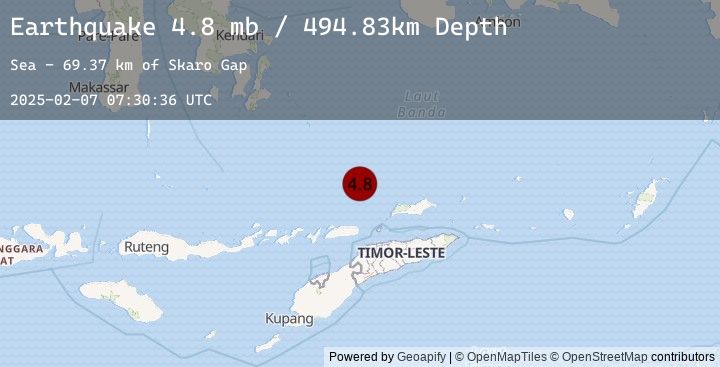
A 4.8 magnitude earthquake struck on 150 km N of Likisá, Timor Leste, at Fri, 07 Feb 2025 07:30:36 GMT. Depth: 494.83km. Reviewed by USGS seismologists, this light quake occurred at a magnitude type of mb.
Magnitude
4.8
mb
Source
USGS
Intensity
-
Earthquake Details
ConfirmedEvent IDusgs_us7000pc28
Tsunami PotentialNo
Magnitude Typemb
Nearest Places
- Skaro Gap69.3 km
- Soekarno Seamounts76.0 km
- Skaro Kacil Seamount82.6 km
- Kadola Seamount86.5 km
- Ina Lao Seamount95.6 km
Comments
Join the discussion about this event.
Latest Earthquakes
1.1Mag
4 km E of Woodcrest, CA
Time3 minutes ago
Depth14.49 km
SourceUSGS (Automatic)
3.0Mag
SOUTH ISLAND OF NEW ZEALAND
Time6 minutes ago
Depth176.10 km
SourceEMSC (Automatic)
2.6Mag
Sumbawa Region, Indonesia
Time14 minutes ago
Depth23.60 km
SourceBMKG (Automatic)
2.6Mag
SUMBAWA REGION, INDONESIA
Time14 minutes ago
Depth24.00 km
SourceEMSC (Automatic)
2.0Mag
Sumbawa Region, Indonesia
Time18 minutes ago
Depth2.18 km
SourceBMKG (Automatic)
Nearby Earthquakes
No significant earthquakes nearby recently.