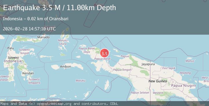
Earthquake near the north coast of Papua, Indonesia
Sat, 28 Feb 2026 14:57:11 GMT
Time1 hour ago
Location
-1.2806, 134.1639
Depth
20.4 KM
Event Summary
A 3.5 magnitude earthquake struck on near the north coast of Papua, Indonesia, at Sat, 28 Feb 2026 14:57:11 GMT. Depth: 20.3857421875km. Reviewed by VYT seismologists, this minor quake occurred at a magnitude type of earthquake.
Magnitude
3.5
earthquake
Source
VYT
Intensity
-
Agency Reports
2 Sources| Source | Magnitude | Depth | Time |
|---|---|---|---|
| VYTPrimary | 3.3 | 20 km | 1 hour ago |
| BMKG | 3.5 | 11 km | 1 hour ago |
Earthquake Details
AutomaticEvent IDvyt_15z4q797vdjyq
Tsunami PotentialNo
Magnitude Typeearthquake
Nearest Places
- 1.5 km
- 2.2 km
- 3.1 km
- 4.3 km
- 4.8 km
Comments
Join the discussion about this event.
Latest Earthquakes
3.8Mag
Minahasa, Sulawesi, Indonesia
Time1 hour ago
Depth7.81 km
SourceVYT (Automatic)
1.9Mag
Central Alaska
Time1 hour ago
Depth111.45 km
SourceVYT (Automatic)
3.0Mag
Molucca Sea
Time1 hour ago
Depth145.87 km
SourceVYT (Automatic)
1.7Mag
47 km NW of Toyah, Texas
Time1 hour ago
Depth4.01 km
SourceUSGS (Automatic)
1.3Mag
Central Alaska
Time1 hour ago
Depth3.54 km
SourceVYT (Automatic)
Nearby Earthquakes
3.0Mag
NEAR N COAST OF PAPUA, INDONESIA
Time2 months ago
Depth10.00 km
SourceBMKG (Automatic)
3.0Mag
NEAR N COAST OF PAPUA, INDONESIA
Time4 years ago
Depth12.00 km
SourceDJA (Automatic)
2.6Mag
West Papua Region, Indonesia
Time1 hour ago
Depth10.00 km
SourceBMKG
2.5Mag
West Papua Region, Indonesia
Time1 month ago
Depth12.18 km
SourceBMKG (Automatic)
4.0Mag
NEAR N COAST OF PAPUA, INDONESIA
Time4 years ago
Depth12.00 km
SourceDJA (Automatic)