Earthquake California-Baja California border region
Sun, 10 May 2026 09:55:14 GMT
Low Quality Data Warning
This earthquake may be wrong/incorrect, it is recommended not to spread this information because there is a possibility that further updates are needed for data accuracy.
Time10 hours ago
Location
32.7694, -116.1259
Depth
94.6 KM
Event Summary
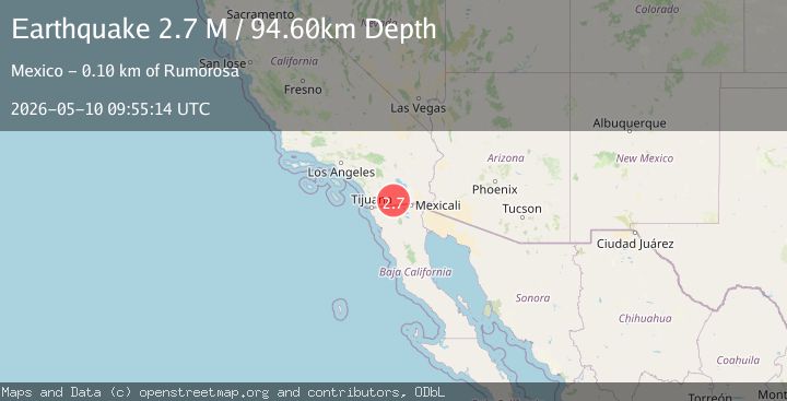
A 2.7 magnitude earthquake struck on California-Baja California border region, at Sun, 10 May 2026 09:55:14 GMT. Depth: 94.6044921875km. Reviewed by VYT seismologists, this minor quake occurred at a magnitude type of M.
Magnitude
2.7
M
Source
VYT
Intensity
-
Agency Reports
3 Sources| Source | Magnitude | Depth | Time |
|---|---|---|---|
| VYTPrimary | 2.7 | 95 km | 10 hours ago |
| SCSN | 2.4 | 10 km | 10 hours ago |
| USGS | 2.4 | 10 km | 10 hours ago |
Earthquake Details
AutomaticEvent IDvyt_1j4s2hq0ywn3a
QualityD
Tsunami PotentialNo
Magnitude TypeM
Last Update10 hours ago
Used Stations57
Total Stations7
Felt Reports0
Did you feel this earthquake? Report it to help others.
No reports yet
Be the first to report this earthquake!
Latest Earthquakes
Loading...
Nearby Earthquakes
1.6Mag
4 km SSW of Brawley, CA
Time10 hours ago
Depth9.42 km
SourceUSGS (Automatic)
1.9Mag
1 km SW of Brawley, CA
Time10 hours ago
Depth7.20 km
SourceUSGS (Automatic)
1.5Mag
0 km NNW of Brawley, CA
Time10 hours ago
Depth7.21 km
SourceUSGS (Automatic)
1.4Mag
2 km SW of Brawley, CA
Time10 hours ago
Depth5.27 km
SourceUSGS (Automatic)
1.4Mag
1 km SSW of Brawley, CA
Time10 hours ago
Depth9.46 km
SourceUSGS (Automatic)