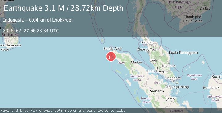
Earthquake northern Sumatra, Indonesia
Fri, 27 Feb 2026 00:23:35 GMT
Time1 hour ago
Location
4.7443, 95.1429
Depth
41.1 KM
Event Summary
A 3.1 magnitude earthquake struck on northern Sumatra, Indonesia, at Fri, 27 Feb 2026 00:23:35 GMT. Depth: 41.1376953125km. Reviewed by VYT seismologists, this minor quake occurred at a magnitude type of earthquake.
Magnitude
3.1
earthquake
Source
VYT
Intensity
-
Agency Reports
2 Sources| Source | Magnitude | Depth | Time |
|---|---|---|---|
| VYTPrimary | 3.1 | 41 km | 1 hour ago |
| BMKG | 3.1 | 29 km | 1 hour ago |
Earthquake Details
AutomaticEvent IDvyt_1jd0b9c7ef5rs
Tsunami PotentialNo
Magnitude Typeearthquake
Nearest Places
- 28.6 km
- 28.8 km
- 28.9 km
- 28.9 km
- 28.9 km
Comments
Join the discussion about this event.
Latest Earthquakes
2.7Mag
Queensland, Australia
Time1 hour ago
Depth10.00 km
SourceVYT (Automatic)
2.2Mag
Channel Islands region, California
Time1 hour ago
Depth10.00 km
SourceVYT (Automatic)
2.4Mag
San Juan, Argentina
Time1 hour ago
Depth10.00 km
SourceVYT (Automatic)
2.1Mag
Sweden
Time1 hour ago
Depth7.57 km
SourceVYT (Automatic)
1.9Mag
Sweden
Time1 hour ago
Depth10.00 km
SourceVYT (Automatic)
Nearby Earthquakes
5.0Mag
NORTHERN SUMATRA, INDONESIA
Time3 years ago
Depth60.00 km
SourceEMSC (Automatic)
5.3Mag
NORTHERN SUMATRA, INDONESIA
Time21 years ago
Depth33.00 km
SourceEMSC (Automatic)
5.0Mag
NORTHERN SUMATRA, INDONESIA
Time10 years ago
Depth60.00 km
SourceEMSC (Automatic)
6.0Mag
NORTHERN SUMATRA, INDONESIA
Time18 years ago
Depth40.00 km
SourceEMSC (Automatic)
5.5Mag
NORTHERN SUMATRA, INDONESIA
Time3 years ago
Depth45.00 km
SourceEMSC (Automatic)