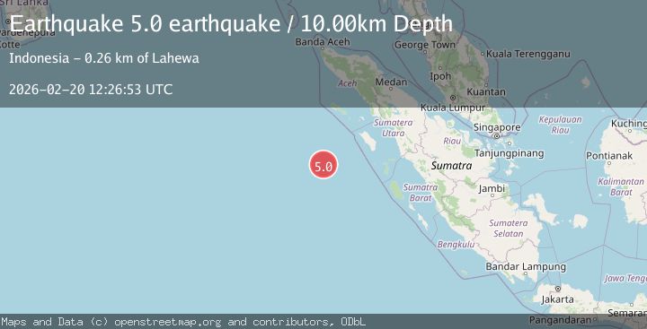
Earthquake southwest of Sumatra, Indonesia
Fri, 20 Feb 2026 12:26:53 GMT
Time1 hour ago
Location
-0.1085, 95.3681
Depth
10.0 KM
Event Summary
A 4.4 magnitude earthquake struck on southwest of Sumatra, Indonesia, at Fri, 20 Feb 2026 12:26:53 GMT. Depth: 10km. Reviewed by VYT seismologists, this light quake occurred at a magnitude type of earthquake.
Magnitude
4.4
earthquake
Source
VYT
Intensity
-
Agency Reports
1 Sources| Source | Magnitude | Depth | Time |
|---|---|---|---|
| VYTPrimary | 4.4 | 10 km | 1 hour ago |
Earthquake Details
AutomaticEvent IDvyt_1kvztuoqpnfgp
Tsunami PotentialNo
Magnitude Typeearthquake
Nearest Places
- Kuenen Rise188.3 km
- Pulau Heruanga239.3 km
- Desa Hanofa240.1 km
- Pulau Asu240.2 km
- Maruhawa240.5 km
Comments
Join the discussion about this event.
Latest Earthquakes
3.3Mag
Jujuy, Argentina
Time1 hour ago
Depth295.78 km
SourceVYT (Automatic)
3.0Mag
Texas-Chihuahua border region
Time1 hour ago
Depth0.00 km
SourceVYT (Automatic)
3.1Mag
Antofagasta, Chile
Time1 hour ago
Depth123.29 km
SourceVYT (Automatic)
1.3Mag
4 km W of Lake Henshaw, CA
Time1 hour ago
Depth11.95 km
SourceUSGS (Automatic)
1.9Mag
Antofagasta, Chile
Time1 hour ago
Depth0.00 km
SourceVYT (Automatic)
Nearby Earthquakes
4.0Mag
OFF W COAST OF NORTHERN SUMATRA
Time3 years ago
Depth10.00 km
SourceNEIC (Automatic)
4.0Mag
SOUTHWEST OF SUMATRA, INDONESIA
Time4 years ago
Depth10.00 km
SourceDJA (Automatic)
4.0Mag
NIAS REGION, INDONESIA
Time4 years ago
Depth10.00 km
SourceDJA (Automatic)
4.0Mag
NIAS REGION, INDONESIA
Time4 years ago
Depth10.00 km
SourceDJA (Automatic)
4.0Mag
SOUTHWEST OF SUMATRA, INDONESIA
Time4 years ago
Depth10.00 km
SourceDJA (Automatic)