Earthquake California-Baja California border region
Fri, 13 Feb 2026 10:49:39 GMT
Time1 week ago
Location
32.3282, -115.3573
Depth
12.6 KM
Event Summary
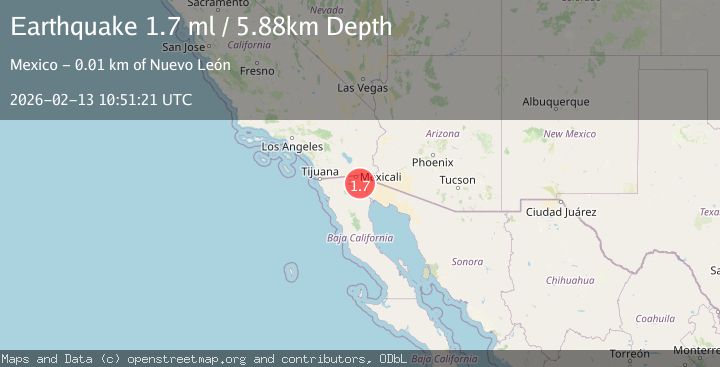
A 2.0 magnitude earthquake struck on California-Baja California border region, at Fri, 13 Feb 2026 10:49:39 GMT. Depth: 12.5732421875km. Reviewed by VYT seismologists, this minor quake occurred at a magnitude type of earthquake.
Magnitude
2.0
earthquake
Source
VYT
Intensity
-
Agency Reports
2 Sources| Source | Magnitude | Depth | Time |
|---|---|---|---|
| VYTPrimary | 2.0 | 5 km | 1 week ago |
| USGS | 1.7 | 6 km | 1 week ago |
Earthquake Details
AutomaticEvent IDvyt_1mi1ktugzc7jt
Tsunami PotentialNo
Magnitude Typeearthquake
Nearest Places
- 2.5 km
- 2.9 km
- 3.5 km
- 3.6 km
- 3.9 km
Comments
Join the discussion about this event.
Latest Earthquakes
2.1Mag
Bali Region, Indonesia
Time5 minutes ago
Depth92.22 km
SourceBMKG
3.8Mag
offshore Atacama, Chile
Time11 minutes ago
Depth18.80 km
SourceVYT (Automatic)
0.7Mag
5 km W of Cobb, CA
Time11 minutes ago
Depth1.83 km
SourceUSGS (Automatic)
1.5Mag
Southern Alaska
Time13 minutes ago
Depth0.00 km
SourceVYT (Automatic)
3.0Mag
Halmahera, Indonesia
Time27 minutes ago
Depth4.64 km
SourceBMKG
Nearby Earthquakes
2.5Mag
18 km W of Delta, B.C., MX
Time2 hours ago
Depth10.16 km
SourceUSGS (Automatic)
3.0Mag
BAJA CALIFORNIA, MEXICO
Time3 years ago
Depth10.00 km
SourceNEIC (Automatic)
3.0Mag
BAJA CALIFORNIA, MEXICO
Time4 years ago
Depth10.00 km
SourceNEIC (Automatic)
2.0Mag
BAJA CALIFORNIA, MEXICO
Time2 weeks ago
Depth2.70 km
SourceSCSN (Automatic)
2.0Mag
BAJA CALIFORNIA, MEXICO
Time2 weeks ago
Depth8.40 km
SourceSCSN (Automatic)