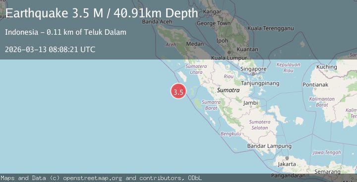
Earthquake southwest of Sumatra, Indonesia
Fri, 13 Mar 2026 08:08:19 GMT
Low Quality Data Warning
This earthquake may be wrong/incorrect, it is recommended not to spread this information because there is a possibility that further updates are needed for data accuracy.
Time3 weeks ago
Location
-0.2770, 97.1021
Depth
31.4 KM
Event Summary
A 3.7 magnitude earthquake struck on southwest of Sumatra, Indonesia, at Fri, 13 Mar 2026 08:08:19 GMT. Depth: 31.3720703125km. Reviewed by VYT seismologists, this minor quake occurred at a magnitude type of M.
Magnitude
3.7
M
Source
VYT
Intensity
-
Agency Reports
2 Sources| Source | Magnitude | Depth | Time |
|---|---|---|---|
| VYTPrimary | 3.7 | 31 km | 3 weeks ago |
| BMKG | 3.5 | 41 km | 3 weeks ago |
Earthquake Details
AutomaticEvent IDvyt_1rk2ngkr5e11f
QualityD
Tsunami PotentialNo
Magnitude TypeM
Last Update3 weeks ago
Total Stations5
Felt Reports0
Did you feel this earthquake? Report it to help others.
No reports yet
Be the first to report this earthquake!
Latest Earthquakes
Loading...
Nearby Earthquakes
3.0Mag
Southwest of Sumatra, Indonesia
Time1 day ago
Depth21.24 km
SourceBMKG
4.9Mag
northern Sumatra, Indonesia
Time2 days ago
Depth36.50 km
SourceVYT (Automatic)
3.1Mag
NIAS REGION, INDONESIA
Time1 week ago
Depth10.00 km
SourceBMKG (Automatic)
3.5Mag
off the west coast of northern Sumatra
Time2 weeks ago
Depth79.35 km
SourceVYT (Automatic)
3.3Mag
off the west coast of northern Sumatra
Time3 weeks ago
Depth11.84 km
SourceVYT (Automatic)