Earthquake Bali Sea
Fri, 13 Feb 2026 18:32:40 GMT
Time1 week ago
Location
-7.6440, 117.4468
Depth
10.4 KM
Event Summary
A 3.7 magnitude earthquake struck on Bali Sea, at Fri, 13 Feb 2026 18:32:40 GMT. Depth: 10.3759765625km. Reviewed by VYT seismologists, this minor quake occurred at a magnitude type of earthquake.
Magnitude
3.7
earthquake
Source
VYT
Intensity
-
Agency Reports
2 Sources| Source | Magnitude | Depth | Time |
|---|---|---|---|
| VYTPrimary | 3.7 | 10 km | 1 week ago |
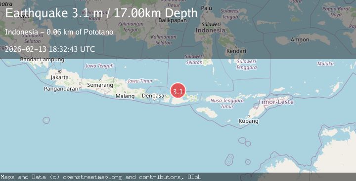
| BMKG | 3.1 | 17 km | 1 week ago |
Earthquake Details
AutomaticEvent IDvyt_2mnqnc0vsrct5
Tsunami PotentialNo
Magnitude Typeearthquake
Nearest Places
- 6.8 km
- 6.8 km
- 13.4 km
- 13.4 km
- 17.1 km
Comments
Join the discussion about this event.
Latest Earthquakes
1.9Mag
Southern California
Time6 minutes ago
Depth11.11 km
SourceVYT (Automatic)
1.9Mag
Sweden
Time8 minutes ago
Depth11.84 km
SourceVYT (Automatic)
0.8Mag
9 km NNW of Perryville, Alaska
Time10 minutes ago
Depth118.40 km
SourceUSGS (Automatic)
0.5Mag
Northern Territory, Australia
Time13 minutes ago
Depth5.00 km
SourceVYT (Automatic)
3.5Mag
OFF E. COAST OF N. ISLAND, N.Z.
Time16 minutes ago
Depth207.40 km
SourceGNS (Automatic)
Nearby Earthquakes
2.3Mag
Bali Sea
Time2 weeks ago
Depth10.00 km
SourceBMKG (Automatic)
3.0Mag
BALI SEA
Time1 year ago
Depth15.00 km
SourceBMKG (Automatic)
4.0Mag
Bali Sea
Time1 week ago
Depth7.57 km
SourceVYT (Automatic)
4.0Mag
BALI SEA
Time1 year ago
Depth299.00 km
SourceEMSC (Automatic)
2.3Mag
Bali Sea
Time0 months ago
Depth10.00 km
SourceBMKG (Automatic)