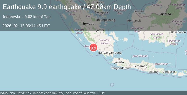
Earthquake southern Sumatra, Indonesia
Sun, 15 Feb 2026 06:14:45 GMT
Time4 days ago
Location
-4.2248, 102.5095
Depth
47.0 KM
Event Summary
A 9.9 magnitude earthquake struck on southern Sumatra, Indonesia, at Sun, 15 Feb 2026 06:14:45 GMT. Depth: 46.9970703125km. Reviewed by VYT seismologists, this major quake occurred at a magnitude type of earthquake.
Magnitude
9.9
earthquake
Source
VYT
Intensity
-
Agency Reports
1 Sources| Source | Magnitude | Depth | Time |
|---|---|---|---|
| VYTPrimary | 9.9 | 47 km | 4 days ago |
Earthquake Details
AutomaticEvent IDvyt_2xbvj74ggq7g8
Tsunami PotentialNo
Magnitude Typeearthquake
Nearest Places
- Desa Padang Genting9.6 km
- Pasarseluma9.6 km
- Desa Padang Merbau9.8 km
- Air Penago9.9 km
- Desa Rawah Indah10.2 km
Comments
Join the discussion about this event.
Latest Earthquakes
2.6Mag
Sulawesi, Indonesia
Time22 hours ago
Depth10.00 km
SourceBMKG
1.1Mag
British Columbia, Canada
Time22 hours ago
Depth16.24 km
SourceVYT (Automatic)
3.4Mag
NEAR COAST OF NICARAGUA
Time22 hours ago
Depth36.00 km
SourceINET (Automatic)
2.2Mag
DODECANESE IS.-TURKEY BORDER REG
Time22 hours ago
Depth5.00 km
SourceKOERI (Automatic)
2.7Mag
South Australia
Time23 hours ago
Depth264.28 km
SourceVYT (Automatic)
Nearby Earthquakes
5.2Mag
SOUTHERN SUMATRA, INDONESIA
Time4 years ago
Depth60.00 km
SourceEMSC (Automatic)
5.2Mag
SOUTHERN SUMATRA, INDONESIA
Time4 years ago
Depth60.00 km
SourceEMSC (Automatic)
3.0Mag
SOUTHERN SUMATRA, INDONESIA
Time2 years ago
Depth37.00 km
SourceBMKG (Automatic)
3.0Mag
SOUTHERN SUMATRA, INDONESIA
Time3 months ago
Depth37.00 km
SourceBMKG (Automatic)
5.3Mag
SOUTHERN SUMATRA, INDONESIA
Time17 years ago
Depth30.00 km
SourceEMSC (Automatic)