Earthquake Papua, Indonesia
Thu, 12 Feb 2026 20:38:48 GMT
Time6 days ago
Location
-3.0244, 136.0318
Depth
1.7 KM
Event Summary
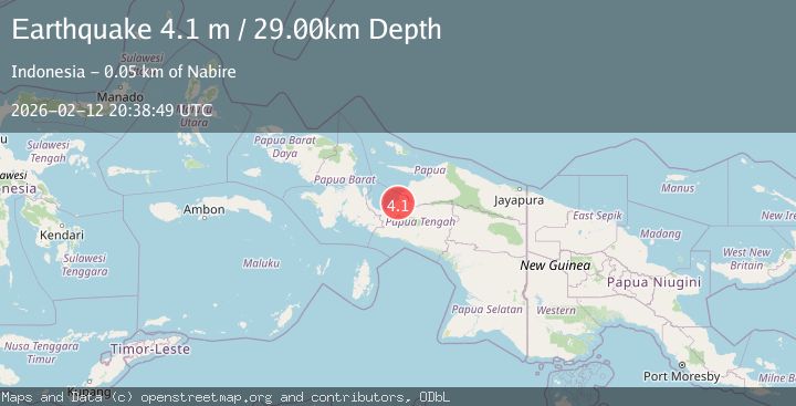
A 4.1 magnitude earthquake struck on Papua, Indonesia, at Thu, 12 Feb 2026 20:38:48 GMT. Depth: 1.708984375km. Reviewed by VYT seismologists, this light quake occurred at a magnitude type of earthquake.
Magnitude
4.1
earthquake
Source
VYT
Intensity
-
Agency Reports
2 Sources| Source | Magnitude | Depth | Time |
|---|---|---|---|
| VYTPrimary | 3.9 | 2 km | 6 days ago |
| BMKG | 4.1 | 29 km | 6 days ago |
Earthquake Details
AutomaticEvent IDvyt_2zzif740l1psk
Tsunami PotentialNo
Magnitude Typeearthquake
Nearest Places
- Kampung Napan10.9 km
- Distrik Napan11.8 km
- Kampung Taumi12.3 km
- Siriwo15.4 km
- Aigiehe15.7 km
Comments
Join the discussion about this event.
Latest Earthquakes
2.1Mag
Flores Region, Indonesia
Time3 minutes ago
Depth165.90 km
SourceBMKG
2.4Mag
Sumbawa region, Indonesia
Time4 minutes ago
Depth19.65 km
SourceVYT (Automatic)
2.1Mag
Poland
Time7 minutes ago
Depth1.95 km
SourceVYT (Automatic)
1.7Mag
2 km NW of Enterprise, Nevada
Time15 minutes ago
Depth15.89 km
SourceUSGS (Automatic)
1.3Mag
Southeastern Alaska
Time17 minutes ago
Depth7.20 km
SourceVYT (Automatic)
Nearby Earthquakes
5.3Mag
PAPUA, INDONESIA
Time13 years ago
Depth15.00 km
SourceEMSC (Automatic)
5.2Mag
PAPUA, INDONESIA
Time20 years ago
Depth40.00 km
SourceEMSC (Automatic)
4.0Mag
NEAR N COAST OF PAPUA, INDONESIA
Time5 years ago
Depth14.00 km
SourceDJA (Automatic)
3.6Mag
West Papua Region, Indonesia
Time0 months ago
Depth10.00 km
SourceBMKG (Automatic)
3.0Mag
PAPUA, INDONESIA
Time1 year ago
Depth10.00 km
SourceBMKG (Automatic)