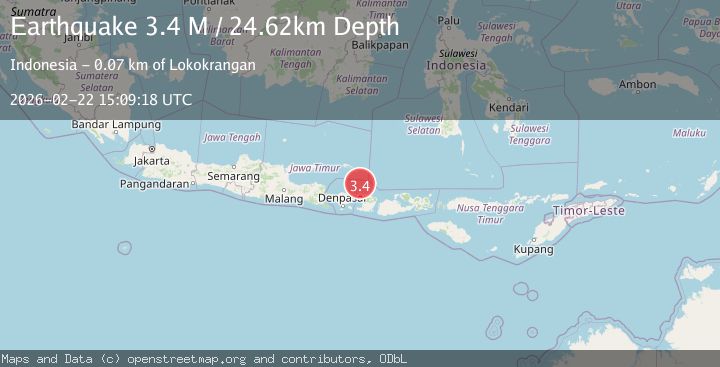
Earthquake Bali region, Indonesia
Sun, 22 Feb 2026 15:09:24 GMT
Time1 hour ago
Location
-8.1272, 115.9493
Depth
22.6 KM
Event Summary
A 2.9 magnitude earthquake struck on Bali region, Indonesia, at Sun, 22 Feb 2026 15:09:24 GMT. Depth: 22.5830078125km. Reviewed by VYT seismologists, this minor quake occurred at a magnitude type of earthquake.
Magnitude
2.9
earthquake
Source
VYT
Intensity
-
Agency Reports
1 Sources| Source | Magnitude | Depth | Time |
|---|---|---|---|
| VYTPrimary | 2.9 | 23 km | 1 hour ago |
Earthquake Details
AutomaticEvent IDvyt_32m1tel3e5hk2
Tsunami PotentialNo
Magnitude Typeearthquake
Nearest Places
- 25.5 km
- 25.5 km
- 25.6 km
- 25.9 km
- 25.9 km
Comments
Join the discussion about this event.
Latest Earthquakes
2.4Mag
Ceram Sea
Time1 hour ago
Depth98.36 km
SourceBMKG
2.8Mag
CENTRAL CALIFORNIA
Time1 hour ago
Depth3.80 km
SourceNC (Automatic)
3.0Mag
Tarapaca, Chile
Time1 hour ago
Depth104.13 km
SourceVYT (Automatic)
2.3Mag
NORTHERN CALIFORNIA
Time1 hour ago
Depth3.40 km
SourceNC (Automatic)
2.8Mag
OFF COAST OF COSTA RICA
Time1 hour ago
Depth10.00 km
SourceUNA (Automatic)
Nearby Earthquakes
3.0Mag
BALI REGION, INDONESIA
Time5 years ago
Depth12.00 km
SourceDJA (Automatic)
3.0Mag
BALI REGION, INDONESIA
Time1 year ago
Depth243.00 km
SourceBMKG (Automatic)
3.0Mag
BALI REGION, INDONESIA
Time3 years ago
Depth12.00 km
SourceDJA (Automatic)
4.0Mag
LOMBOK REGION, INDONESIA
Time7 years ago
Depth12.00 km
SourceDJA (Automatic)
2.5Mag
LOMBOK REGION, INDONESIA
Time2 months ago
Depth13.00 km
SourceBMKG (Automatic)