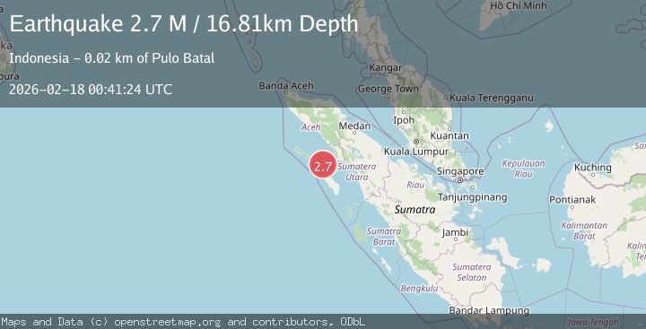
Earthquake northern Sumatra, Indonesia
Wed, 18 Feb 2026 00:41:30 GMT
Time11 hours ago
Location
2.4554, 97.3536
Depth
3.4 KM
Event Summary
A 2.3 magnitude earthquake struck on northern Sumatra, Indonesia, at Wed, 18 Feb 2026 00:41:30 GMT. Depth: 3.41796875km. Reviewed by VYT seismologists, this minor quake occurred at a magnitude type of earthquake.
Magnitude
2.3
earthquake
Source
VYT
Intensity
-
Agency Reports
1 Sources| Source | Magnitude | Depth | Time |
|---|---|---|---|
| VYTPrimary | 2.3 | 3 km | 11 hours ago |
Earthquake Details
AutomaticEvent IDvyt_33ibeycy2uoyi
Tsunami PotentialNo
Magnitude Typeearthquake
Nearest Places
- Gampong Teluk Nibung12.7 km
- Pulau Ujung Batu13.5 km
- Gampong Pulau Balai16.1 km
- Pulau Delapan17.6 km
- Pulau Orongan17.8 km
Comments
Join the discussion about this event.
Latest Earthquakes
1.9Mag
Southern Alaska
Time11 hours ago
Depth0.00 km
SourceVYT (Automatic)
2.5Mag
Antofagasta, Chile
Time11 hours ago
Depth111.21 km
SourceVYT (Automatic)
2.8Mag
Tarapaca, Chile
Time11 hours ago
Depth89.11 km
SourceVYT (Automatic)
2.5Mag
LA RIOJA, ARGENTINA
Time11 hours ago
Depth124.00 km
SourceNSNA (Automatic)
1.9Mag
WESTERN TURKEY
Time11 hours ago
Depth7.00 km
SourceAFAD (Automatic)
Nearby Earthquakes
3.0Mag
NORTHERN SUMATRA, INDONESIA
Time3 years ago
Depth24.00 km
SourceDJA (Automatic)
3.0Mag
NORTHERN SUMATRA, INDONESIA
Time1 year ago
Depth25.00 km
SourceBMKG (Automatic)
5.0Mag
NORTHERN SUMATRA, INDONESIA
Time20 years ago
Depth33.00 km
SourceEMSC (Automatic)
3.0Mag
NORTHERN SUMATRA, INDONESIA
Time3 years ago
Depth10.00 km
SourceDJA (Automatic)
5.8Mag
NORTHERN SUMATRA, INDONESIA
Time20 years ago
Depth10.00 km
SourceEMSC (Automatic)