Earthquake Banda Sea
Fri, 13 Feb 2026 02:02:17 GMT
Time5 days ago
Location
-6.5597, 130.2146
Depth
171.3 KM
Event Summary
A 4.7 magnitude earthquake struck on Banda Sea, at Fri, 13 Feb 2026 02:02:17 GMT. Depth: 171.2646484375km. Reviewed by VYT seismologists, this light quake occurred at a magnitude type of earthquake.
Magnitude
4.7
earthquake
Source
VYT
Intensity
-
Agency Reports
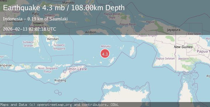
4 Sources| Source | Magnitude | Depth | Time |
|---|---|---|---|
| VYTPrimary | 4.5 | 171 km | 5 days ago |
| BMKG | 4.7 | 87 km | 5 days ago |
| NEIC | 4.5 | 114 km | 5 days ago |
| EMSC | 4.3 | 108 km | 5 days ago |
Earthquake Details
AutomaticEvent IDvyt_361qm1elduend
Tsunami PotentialNo
Magnitude Typeearthquake
Nearest Places
- Waru34.3 km
- Pulau Serua35.4 km
- Trana36.0 km
- Lesluru36.4 km
- Pulau Kekeh Besar38.3 km
Comments
Join the discussion about this event.
Latest Earthquakes
2.5Mag
Tarapaca, Chile
Time1 minute ago
Depth112.55 km
SourceVYT (Automatic)
2.2Mag
Tarapaca, Chile
Time7 minutes ago
Depth111.94 km
SourceVYT (Automatic)
1.9Mag
Central Alaska
Time7 minutes ago
Depth32.10 km
SourceVYT (Automatic)
3.4Mag
HAWAII REGION, HAWAII
Time8 minutes ago
Depth4.70 km
SourceHV (Automatic)
1.9Mag
STRAIT OF GIBRALTAR
Time11 minutes ago
Depth0.00 km
SourceIGN (Automatic)
Nearby Earthquakes
4.0Mag
BANDA SEA
Time5 years ago
Depth194.00 km
SourceDJA (Automatic)
4.0Mag
BANDA SEA
Time7 years ago
Depth160.00 km
SourceNEIC (Automatic)
5.2Mag
BANDA SEA
Time20 years ago
Depth147.00 km
SourceEMSC (Automatic)
5.2Mag
BANDA SEA
Time18 years ago
Depth125.00 km
SourceEMSC (Automatic)
4.0Mag
BANDA SEA
Time7 months ago
Depth218.00 km
SourceBMKG (Automatic)