Earthquake south of Bali, Indonesia
Mon, 16 Feb 2026 19:23:38 GMT
Time2 days ago
Location
-9.2511, 115.2958
Depth
11.5 KM
Event Summary
A 4.8 magnitude earthquake struck on south of Bali, Indonesia, at Mon, 16 Feb 2026 19:23:38 GMT. Depth: 11.474609375km. Reviewed by VYT seismologists, this light quake occurred at a magnitude type of earthquake.
Magnitude
4.8
earthquake
Source
VYT
Intensity
-
Agency Reports
2 Sources| Source | Magnitude | Depth | Time |
|---|---|---|---|
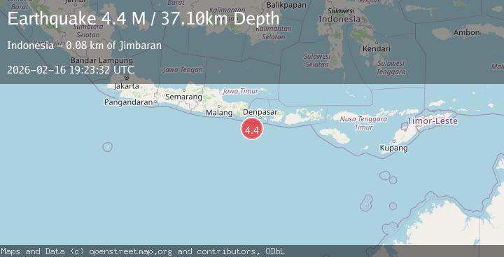
| VYTPrimary | 4.8 | 76 km | 2 days ago |
| BMKG | 4.4 | 37 km | 2 days ago |
Earthquake Details
AutomaticEvent IDvyt_3f3ubjip8gde2
Tsunami PotentialNo
Magnitude Typeearthquake
Nearest Places
- Bumi Linggah The Pratama Villas43.4 km
- Tukad Celagimanis46.8 km
- Tukad Gerombong46.9 km
- Tukad Mejan46.9 km
- Tukad Babi46.9 km
Comments
Join the discussion about this event.
Latest Earthquakes
2.9Mag
Antofagasta, Chile
Time2 hours ago
Depth109.25 km
SourceVYT (Automatic)
1.9Mag
Andreanof Islands, Aleutian Islands, Alaska
Time2 hours ago
Depth0.85 km
SourceVYT (Automatic)
0.9Mag
Washington
Time2 hours ago
Depth0.00 km
SourceVYT (Automatic)
2.7Mag
western Texas
Time2 hours ago
Depth1.34 km
SourceVYT (Automatic)
2.7Mag
Fox Islands, Aleutian Islands, Alaska
Time2 hours ago
Depth18.07 km
SourceVYT (Automatic)
Nearby Earthquakes
3.0Mag
SOUTH OF BALI, INDONESIA
Time4 years ago
Depth20.00 km
SourceDJA (Automatic)
3.0Mag
SOUTH OF BALI, INDONESIA
Time3 years ago
Depth67.00 km
SourceDJA (Automatic)
2.6Mag
SOUTH OF BALI, INDONESIA
Time1 month ago
Depth78.00 km
SourceBMKG (Automatic)
3.0Mag
SOUTH OF BALI, INDONESIA
Time1 year ago
Depth17.00 km
SourceBMKG (Automatic)
3.0Mag
SOUTH OF BALI, INDONESIA
Time10 months ago
Depth44.00 km
SourceBMKG (Automatic)