Earthquake southern Sumatra, Indonesia
Tue, 17 Mar 2026 21:12:40 GMT
Low Quality Data Warning
This earthquake may be wrong/incorrect, it is recommended not to spread this information because there is a possibility that further updates are needed for data accuracy.
Time2 weeks ago
Location
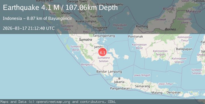
-2.0973, 104.2712
Depth
107.1 KM
Event Summary
A 4.1 magnitude earthquake struck on southern Sumatra, Indonesia, at Tue, 17 Mar 2026 21:12:40 GMT. Depth: 107.0556640625km. Reviewed by VYT seismologists, this light quake occurred at a magnitude type of M.
Magnitude
4.1
M
Source
VYT
Intensity
I
Agency Reports
1 Sources| Source | Magnitude | Depth | Time |
|---|---|---|---|
| VYTPrimary | 4.1 | 107 km | 2 weeks ago |
Earthquake Details
AutomaticEvent IDvyt_3gbxaxgtp15jk
QualityD
Tsunami PotentialNo
Magnitude TypeM
Last Update2 weeks ago
Total Stations7
Nearest Places
Possibly felt by: 185.9K
- 65.5 km
- 76.3 km
- 88.2 km
- 91.4 km606.2K people
- 94.6 km36.7K people
- 99.1 km
- 99.1 km26.7K people
- 99.8 km
- 100.0 km
- 100.9 km
- 105.3 km1.7M people
- 109.3 km
- 111.4 km8K people
- 111.8 km
- 114.0 km
- 116.7 km
- 117.4 km
- 120.3 km
- 123.3 km
- 125.6 km
- 128.3 km
- 135.1 km
Felt Reports0
Did you feel this earthquake? Report it to help others.
No reports yet
Be the first to report this earthquake!
Latest Earthquakes
Loading...