Earthquake southwest of Sumatra, Indonesia
Sun, 22 Mar 2026 03:51:47 GMT
Time2 weeks ago
Location
-6.4093, 103.7066
Depth
6.0 KM
Event Summary
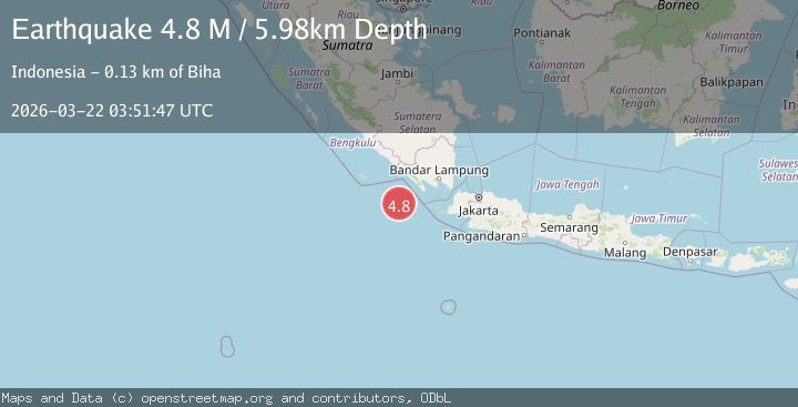
A 4.8 magnitude earthquake struck on southwest of Sumatra, Indonesia, at Sun, 22 Mar 2026 03:51:47 GMT. Depth: 5.9814453125km. Reviewed by VYT seismologists, this light quake occurred at a magnitude type of M.
Magnitude
4.8
M
Source
VYT
Intensity
II
Agency Reports
5 Sources| Source | Magnitude | Depth | Time |
|---|---|---|---|
| VYTPrimary | 4.8 | 6 km | 2 weeks ago |
| BMKG | 4.7 | 10 km | 2 weeks ago |
| USGS | 4.7 | 35 km | 2 weeks ago |
| NEIC | 4.7 | 35 km | 2 weeks ago |
| EMSC | 4.7 | 47 km | 2 weeks ago |
Earthquake Details
AutomaticEvent IDvyt_3voxqy9n7j2sq
QualityA
Tsunami PotentialNo
Magnitude TypeM
Last Update2 weeks ago
Used Stations60
Total Stations195
Nearest Places
Possibly felt by: 116.8K
- IIBiha125.3 km
- IIKrui137.7 km
- 143.5 km
- 144.7 km
- 152.9 km
- ILiwa158.1 km
- 166.6 km
- 166.8 km
- 177.7 km
- 179.5 km
- 182.1 km
- 182.6 km
- 184.0 km
- 187.4 km
- 189.1 km
- 191.3 km
- 191.4 km
- 197.2 km
- 197.3 km
- 203.6 km1.2M people
- 203.8 km
- 203.9 km
- 204.7 km
- 204.9 km
- 205.5 km
- 206.2 km
- 206.4 km
- 211.8 km
- 212.5 km
- 212.7 km
- 217.0 km
- 219.0 km42.4K people
- 220.3 km
- 220.9 km
- 221.4 km
- 224.0 km
- 224.4 km
- 224.5 km
- 225.8 km
- 228.3 km168.6K people
- 230.0 km
- 230.3 km
- 230.7 km
- 230.9 km
- 231.1 km
- 231.2 km
- 232.3 km
- 233.7 km
- 233.9 km
- 234.7 km33.6K people
- 234.9 km
- 237.7 km
- 238.2 km
- 238.6 km52.6K people
- 238.7 km
- 238.8 km
- 240.5 km
- 241.1 km
- 241.2 km
- 241.8 km
- 243.0 km
- 243.8 km
Felt Reports0
Did you feel this earthquake? Report it to help others.
No reports yet
Be the first to report this earthquake!
Latest Earthquakes
Loading...
Nearby Earthquakes
3.9Mag
southwest of Sumatra, Indonesia
Time8 hours ago
Depth34.18 km
SourceVYT (Automatic)
2.4Mag
Sunda Strait, Indonesia
Time23 hours ago
Depth18.60 km
SourceBMKG
4.4Mag
Southern Sumatra, Indonesia
Time2 days ago
Depth33.35 km
SourceBMKG
4.7Mag
southwest of Sumatra, Indonesia
Time2 days ago
Depth0.00 km
SourceVYT (Automatic)
2.9Mag
southern Sumatra, Indonesia
Time2 days ago
Depth43.82 km
SourceVYT (Automatic)