Earthquake Minahasa, Sulawesi, Indonesia
Tue, 17 Feb 2026 02:14:44 GMT
Time1 day ago
Location
-0.4540, 122.1908
Depth
0.0 KM
Event Summary
A 2.7 magnitude earthquake struck on Minahasa, Sulawesi, Indonesia, at Tue, 17 Feb 2026 02:14:44 GMT. Depth: 0km. Reviewed by VYT seismologists, this minor quake occurred at a magnitude type of earthquake.
Magnitude
2.7
earthquake
Source
VYT
Intensity
-
Agency Reports
2 Sources| Source | Magnitude | Depth | Time |
|---|---|---|---|
| VYTPrimary | 2.7 | 0 km | 1 day ago |
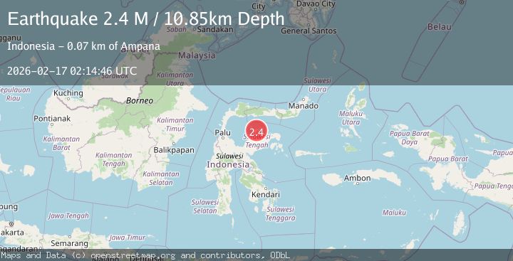
| BMKG | 2.4 | 11 km | 1 day ago |
Earthquake Details
AutomaticEvent IDvyt_3vru8ofuc5trc
Tsunami PotentialNo
Magnitude Typeearthquake
Nearest Places
- Tanjung Uting6.4 km
- Pulau Bangkao6.9 km
- Tanjung Bembe7.6 km
- Tanjung Talipoa8.0 km
- Kepulauan Layang8.8 km
Comments
Join the discussion about this event.
Latest Earthquakes
2.6Mag
Antofagasta, Chile
Time3 hours ago
Depth70.19 km
SourceVYT (Automatic)
1.8Mag
northern Alaska
Time3 hours ago
Depth223.88 km
SourceVYT (Automatic)
3.0Mag
Java, Indonesia
Time3 hours ago
Depth29.78 km
SourceBMKG
2.4Mag
Finland-Russia border region
Time3 hours ago
Depth341.92 km
SourceVYT (Automatic)
0.9Mag
8 km W of Cobb, CA
Time4 hours ago
Depth1.53 km
SourceUSGS (Automatic)
Nearby Earthquakes
3.0Mag
SULAWESI, INDONESIA
Time5 years ago
Depth10.00 km
SourceDJA (Automatic)
5.2Mag
SULAWESI, INDONESIA
Time2 years ago
Depth10.00 km
SourceEMSC (Automatic)
3.0Mag
SULAWESI, INDONESIA
Time5 years ago
Depth10.00 km
SourceDJA (Automatic)
3.0Mag
SULAWESI, INDONESIA
Time2 months ago
Depth13.00 km
SourceBMKG (Automatic)
4.0Mag
SULAWESI, INDONESIA
Time5 years ago
Depth24.00 km
SourceNEIC (Automatic)