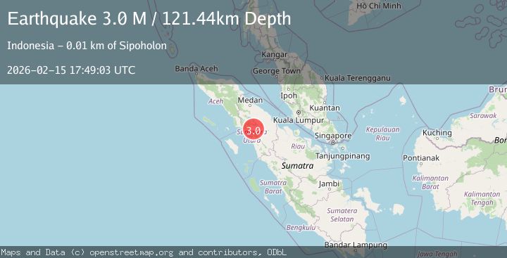
Earthquake northern Sumatra, Indonesia
Sun, 15 Feb 2026 17:49:04 GMT
Time4 days ago
Location
2.1776, 98.9466
Depth
123.5 KM
Event Summary
A 3.5 magnitude earthquake struck on northern Sumatra, Indonesia, at Sun, 15 Feb 2026 17:49:04 GMT. Depth: 123.53515625km. Reviewed by VYT seismologists, this minor quake occurred at a magnitude type of earthquake.
Magnitude
3.5
earthquake
Source
VYT
Intensity
-
Agency Reports
2 Sources| Source | Magnitude | Depth | Time |
|---|---|---|---|
| VYTPrimary | 3.5 | 124 km | 4 days ago |
| BMKG | 3.0 | 121 km | 4 days ago |
Earthquake Details
AutomaticEvent IDvyt_634f2pj81pyi
Tsunami PotentialNo
Magnitude Typeearthquake
Nearest Places
- Tombak Lumban Hoda0.2 km
- Lumban Holting0.3 km
- Hutajulu0.7 km
- Silaban0.8 km
- Desa Banualuhu0.8 km
Comments
Join the discussion about this event.
Latest Earthquakes
2.4Mag
Potosi, Bolivia
Time15 hours ago
Depth239.01 km
SourceVYT (Automatic)
1.3Mag
29 km W of Garden City, Texas
Time15 hours ago
Depth3.35 km
SourceUSGS (Automatic)
2.1Mag
6 km NE of Beaverdam, Nevada
Time15 hours ago
Depth11.45 km
SourceUSGS (Automatic)
3.4Mag
NORTH ISLAND OF NEW ZEALAND
Time16 hours ago
Depth146.90 km
SourceGNS (Automatic)
2.6Mag
WESTERN TURKEY
Time16 hours ago
Depth7.30 km
SourceKOERI (Automatic)
Nearby Earthquakes
5.9Mag
NORTHERN SUMATRA, INDONESIA
Time3 years ago
Depth17.00 km
SourceEMSC (Automatic)
5.1Mag
NORTHERN SUMATRA, INDONESIA
Time15 years ago
Depth54.00 km
SourceEMSC (Automatic)
5.0Mag
NORTHERN SUMATRA, INDONESIA
Time20 years ago
Depth60.00 km
SourceEMSC (Automatic)
3.0Mag
NORTHERN SUMATRA, INDONESIA
Time2 years ago
Depth119.00 km
SourceBMKG (Automatic)
3.0Mag
NORTHERN SUMATRA, INDONESIA
Time3 years ago
Depth10.00 km
SourceDJA (Automatic)