Earthquake Ceram Sea, Indonesia
Sat, 14 Feb 2026 14:21:50 GMT
Time3 days ago
Location
-2.7346, 128.0734
Depth
1.3 KM
Event Summary
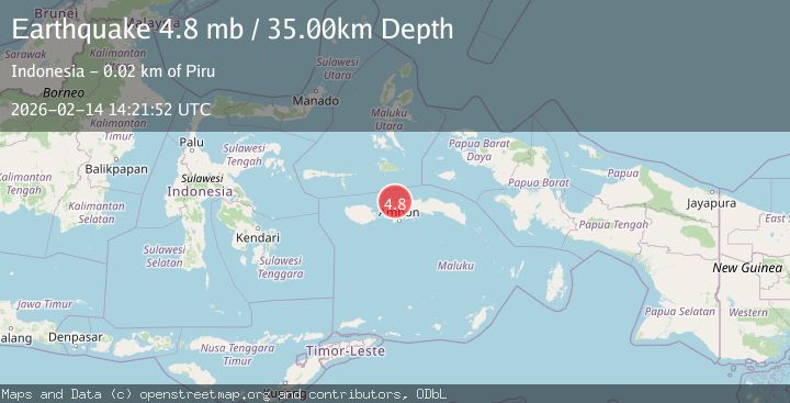
A 5.2 magnitude earthquake struck on Ceram Sea, Indonesia, at Sat, 14 Feb 2026 14:21:50 GMT. Depth: 1.3427734375km. Reviewed by VYT seismologists, this moderate quake occurred at a magnitude type of earthquake.
Magnitude
5.2
earthquake
Source
VYT
Intensity
-
Agency Reports
6 Sources| Source | Magnitude | Depth | Time |
|---|---|---|---|
| VYTPrimary | 5.2 | 1 km | 3 days ago |
| BMKG | 5.2 | 10 km | 3 days ago |
| GFZ | 5.2 | 10 km | 3 days ago |
| EMSC | 5.2 | 52 km | 3 days ago |
| NEIC | 4.8 | 35 km | 3 days ago |
| USGS | 4.8 | 35 km | 3 days ago |
Earthquake Details
AutomaticEvent IDvyt_8azeo2ayuxvb
Tsunami PotentialNo
Magnitude Typeearthquake
Nearest Places
- Tanjung Tandurubesar17.9 km
- Tanjung Tanduru Kecil18.6 km
- Tanjung Sensuraha19.0 km
- Pulau Sirih19.3 km
- Lawau19.5 km
Comments
Join the discussion about this event.
Latest Earthquakes
2.8Mag
Sulawesi, Indonesia
Time1 minute ago
Depth21.08 km
SourceBMKG
2.1Mag
WESTERN TURKEY
Time5 minutes ago
Depth12.30 km
SourceKOERI (Automatic)
2.2Mag
Alaska Peninsula
Time5 minutes ago
Depth57.74 km
SourceVYT (Automatic)
3.7Mag
WESTERN TURKEY
Time8 minutes ago
Depth13.30 km
SourceKOERI (Automatic)
1.6Mag
27 km ESE of Balmorhea, Texas
Time9 minutes ago
Depth3.56 km
SourceUSGS (Automatic)